| Mesoscale Discussion 1465 | |
| < Previous MD Next MD > | |

|
|
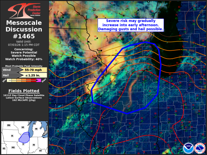
   Mesoscale Discussion 1465
   NWS Storm Prediction Center Norman OK
   1115 AM CDT Fri Jul 03 2026

   Areas affected...portions of northern IL into southeast WI

   Concerning...Severe potential...Watch possible

   Valid 031615Z - 031815Z

   Probability of Watch Issuance...40 percent

   SUMMARY...Thunderstorms may increase in coverage and intensity into
   early afternoon. The strongest storms may produce locally damaging
   gusts and hail. Trends will be monitored for possible watch issuance
   this afternoon.

   DISCUSSION...Isolated storms are moving across northern IL and far
   southern WI at midday. So far, measured gusts with these storms have
   been around 30-35 mph. However, The downstream airmass has been
   mostly sunny through the morning and temperatures have rapidly
   warmed into the mid 80s amid mid/upper 70s dewpoints. This very
   moist airmass beneath modest midlevel lapse rates is allowing for
   moderate to strong destabilization, providing sufficient fuel for
   strong storms. However, vertical shear across the region is expected
   to remain modest, with strong flow focused just to the north of the
   better axis of stronger instability/low-level moisture. Furthermore,
   large-scale ascent remains limited, resulting in uncertainty in how
   well organized convection may be through the day.

   Visible satellite shows additional cumulus development along
   trailing outflow into western/west-central IL, and across the warm
   sector over northern IL into southeast WI. How much additional
   convection develops remains uncertain given nebulous forcing, but
   some risk for locally damaging gusts and isolated hail is possible
   with strongest storms. Trends will be monitored fore possible watch
   issuance this afternoon.

   ..Leitman/Hart.. 07/03/2026

   ...Please see www.spc.noaa.gov for graphic product...

   ATTN...WFO...LOT...ILX...MKX...DVN...

   LAT...LON   42778935 42898895 43028815 42938767 42728746 42128736
               41018755 40498817 40278910 40699082 41189090 41629055
               42778935

   MOST PROBABLE PEAK WIND GUST...55-70 MPH
   MOST PROBABLE PEAK HAIL SIZE...UP TO 1.25 IN
|
|
|
Top/All Mesoscale Discussions/Forecast Products/Home |
|
Source link