| Mesoscale Discussion 1462 | |
| < Previous MD | |

|
|
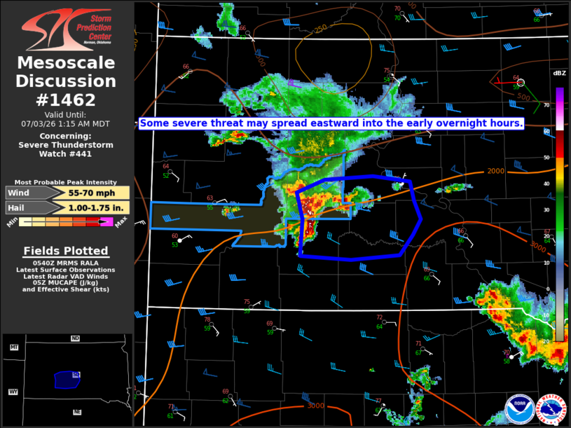
Mesoscale Discussion 1462 NWS Storm Prediction Center Norman OK 1243 AM CDT Fri Jul 03 2026 Areas affected...Parts of southwest/south-central SD Concerning...Severe Thunderstorm Watch 441... Valid 030543Z - 030715Z The severe weather threat for Severe Thunderstorm Watch 441 continues. SUMMARY...Some severe threat may spread eastward into the early overnight hours. DISCUSSION...A small, bowing storm cluster is moving across southwest SD as of 0535 UTC. This cluster is likely somewhat elevated, but MUCAPE of near/above 2000 J/kg and moderate deep-layer shear (as analyzed in recent objective mesoanalyses) within a low-level warm-advection regime will help to maintain this cluster in the short term as it moves eastward. Recent observed wind gusts have generally been subsevere, and this trend may continue given the downstream low-level stability. However, localized severe gusts cannot be ruled out given the current organized nature of this cluster. Isolated hail will also be possible, though the primarily linear mode may temper this threat. The current expectation is for the severe threat to remain relatively isolated. However, this system will continue to be monitored for any uptick in the organized-severe threat (and any need for downstream watch issuance) into the overnight hours. ..Dean/Mosier.. 07/03/2026 ...Please see www.spc.noaa.gov for graphic product... ATTN...WFO...ABR...UNR... LAT...LON 43590179 43620179 43990177 44280186 44410143 44460070 44400014 44190009 43999999 43810010 43600030 43550104 43590179 MOST PROBABLE PEAK WIND GUST...55-70 MPH MOST PROBABLE PEAK HAIL SIZE...1.00-1.75 IN |
|
|
Top/All Mesoscale Discussions/Forecast Products/Home |
|
Source link