| Mesoscale Discussion 1461 | |
| < Previous MD Next MD > | |

|
|
Mesoscale Discussion 1461
NWS Storm Prediction Center Norman OK
1143 PM CDT Thu Jul 02 2026
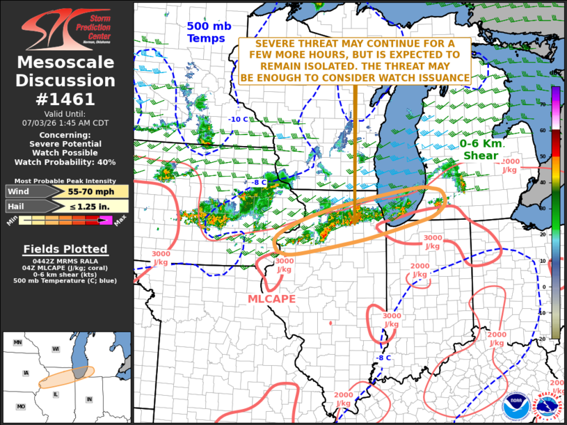
Areas affected...Northern Illinois...Far Northwest Indiana...Far
Southwest Michigan
Concerning...Severe potential...Watch possible
Valid 030443Z - 030645Z
Probability of Watch Issuance...40 percent
SUMMARY...The severe threat may continue for a few more hours across
parts of northern Illinois and far southwest Michigan. Isolated
severe gusts and hail will be the primary threats. The threat may be
enough to consider watch issuance.
DISCUSSION...Latest surface analysis shows an outflow boundary
extending from eastern Iowa east-northeastward into northern
Illinois, along which an east-to-west corridor of strong to severe
storms is ongoing. The storms are located along a relatively tight
gradient of moderate instability, where MLCAPE is estimated by the
RAP in the 2000 to 3000 J/kg range. In addition, the storms are
located along the southern edge of a 40 to 50 knot mid-level jet,
which is providing enough deep-layer shear for organized storms.
Low-level lapse rates are still steep along this instability
gradient, suggesting that a wind-damage threat will continue to be
possible with the stronger storms. Hail could also occur. As
instability decreases in the early overnight period, the severe
threat should eventually decrease.
..Broyles/Guyer.. 07/03/2026
...Please see www.spc.noaa.gov for graphic product...
ATTN...WFO...IWX...GRR...LOT...ILX...DVN...
LAT...LON 41799016 42198865 42538656 42528599 42458571 42258558
42088564 41878595 41738638 41438761 41248855 40939034
40949089 41089109 41379103 41799016
MOST PROBABLE PEAK WIND GUST...55-70 MPH
MOST PROBABLE PEAK HAIL SIZE...UP TO 1.25 IN
|
|
|
Top/All Mesoscale Discussions/Forecast Products/Home |
|
Source link