| Mesoscale Discussion 1460 | |
| < Previous MD | |

|
|
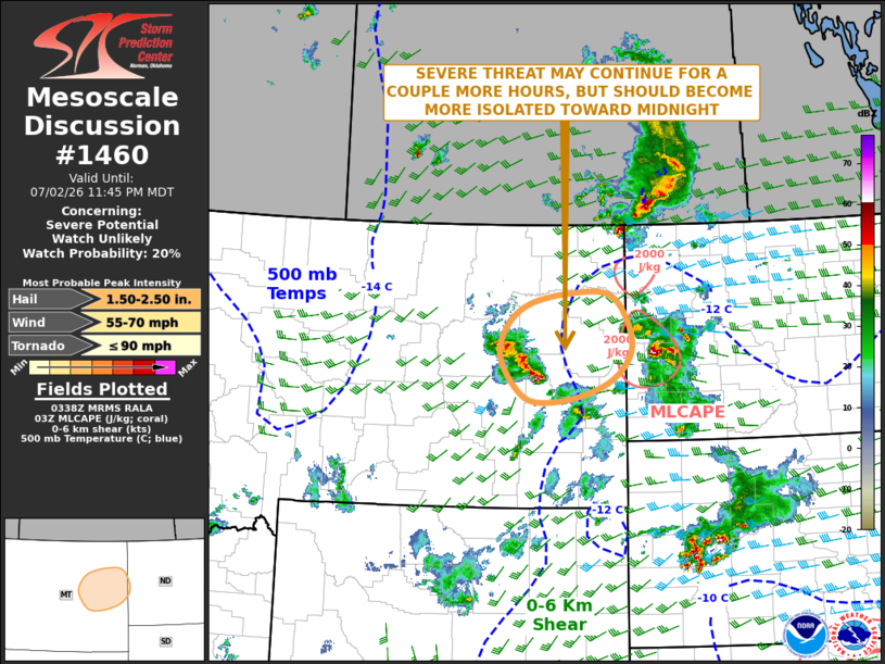
   Mesoscale Discussion 1460
   NWS Storm Prediction Center Norman OK
   1040 PM CDT Thu Jul 02 2026

   Areas affected...Eastern Montana

   Concerning...Severe potential...Watch unlikely

   Valid 030340Z - 030545Z

   Probability of Watch Issuance...20 percent

   SUMMARY...A wind-damage and hail threat will likely continue across
   part of eastern Montana late this evening. The threat is expected to
   become more isolated with time, and additional watch issuance
   appears unlikely.

   DISCUSSION...The latest radar imagery over eastern Montana shows a
   line of strong to severe thunderstorms ongoing about 70 statute
   miles to the south of Glasgow. The storms are located just to the
   northwest of a surface low in an area where surface dewpoints are in
   the mid to upper 50s F, and MLCAPE is estimated by the RAP around
   1000 J/kg. The line currently has a wind-damage threat, which is
   being supported by very steep lapse rates in the low-levels. This
   line may continue to remain intact as it moves toward the
   Montana-North Dakota state line late this evening. Hail could also
   occur within the strongest of cores. However, as instability weakens
   across the region, the line of storms is expected to become more
   disorganized with any severe threat becoming marginal and isolated.

   ..Broyles.. 07/03/2026

   ...Please see www.spc.noaa.gov for graphic product...

   ATTN...WFO...BIS...BYZ...GGW...

   LAT...LON   46490592 46550508 46810433 47200393 47670402 48030441
               48040521 47880604 47590649 47170666 46720636 46490592

   MOST PROBABLE PEAK TORNADO INTENSITY...UP TO 90 MPH
   MOST PROBABLE PEAK WIND GUST...55-70 MPH
   MOST PROBABLE PEAK HAIL SIZE...1.50-2.50 IN
|
|
|
Top/All Mesoscale Discussions/Forecast Products/Home |
|
Source link