| Mesoscale Discussion 1457 | |
| < Previous MD | |

|
|
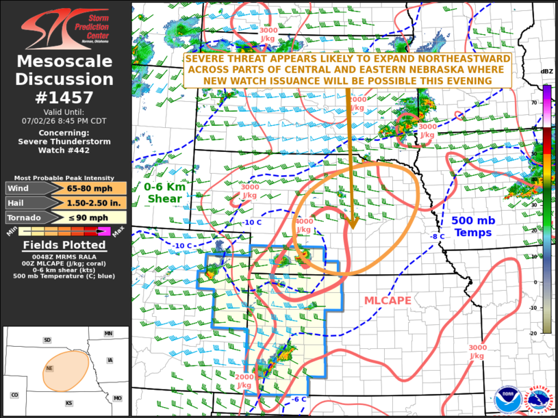
Mesoscale Discussion 1457 NWS Storm Prediction Center Norman OK 0751 PM CDT Thu Jul 02 2026 Areas affected...Central and Eastern Nebraska Concerning...Severe Thunderstorm Watch 442... Valid 030051Z - 030145Z The severe weather threat for Severe Thunderstorm Watch 442 continues. SUMMARY...A severe threat is expected to develop across parts of central and eastern Nebraska this evening. Severe wind gusts and isolated large hail will be possible. Weather watch issuance may be needed this evening. DISCUSSION...The latest surface analysis shows a very moist airmass in place over central and eastern Nebraska, where many observation sites have dewpoints in the lower 70s F. This is contributing to strong instability, with the RAP showing MLCAPE ranging from around 4500 J/kg in southern Nebraska to near 2500 J/kg in northeastern Nebraska. To the west of this axis of instability, a mid-level shortwave trough is evident on water vapor imagery over the central High Plains. As this feature moves eastward into the central Plains and as the low-level jet strengthens, convective coverage is expected to increase. Along and near the axis of instability, the RAP has 0-6 km shear in the 30 to 40 knot range, suggesting that a severe threat will be possible. The primary threat will be damaging wind gusts, but isolated large hail will also be possible. ..Broyles.. 07/03/2026 ...Please see www.spc.noaa.gov for graphic product... ATTN...WFO...FSD...OAX...GID...LBF... LAT...LON 40139832 40799724 41589662 42169654 42469669 42669713 42759800 42559912 42050014 41430059 41020062 40640050 40270008 40039927 40139832 MOST PROBABLE PEAK TORNADO INTENSITY...UP TO 90 MPH MOST PROBABLE PEAK WIND GUST...65-80 MPH MOST PROBABLE PEAK HAIL SIZE...1.50-2.50 IN |
|
|
Top/All Mesoscale Discussions/Forecast Products/Home |
|
Source link