| Mesoscale Discussion 1447 | |
| < Previous MD | |

|
|
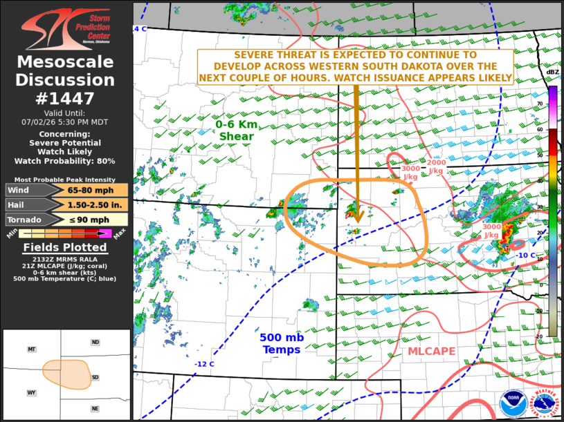
   Mesoscale Discussion 1447
   NWS Storm Prediction Center Norman OK
   0435 PM CDT Thu Jul 02 2026

   Areas affected...Western South Dakota...Far Southeast Montana...Far
   Northeast Wyoming

   Concerning...Severe potential...Watch likely

   Valid 022135Z - 022330Z

   Probability of Watch Issuance...80 percent

   SUMMARY...A severe threat, with a potential for severe wind gusts
   and isolated large hail, is expected to develop across parts of
   western South Dakota over the next couple of hours. The threat could
   extend westward into far southeast Montana and far northeast
   Wyoming. Weather watch issuance appears likely.

   DISCUSSION...A small cluster of strong to severe thunderstorms is
   currently located near Belle Fourche, South Dakota, just to the
   north of the Black Hills. The storms are developing to the northeast
   of a surface low, along an axis of maximized low-level convergence.
   The latest RAP has a corridor of moderate to strong instability
   across central and northwestern South Dakota, where MLCAPE is in the
   2000 to 3000 J/kg range. The storms are moving eastward along the
   southwestern edge of the stronger instability, and appears to be
   supported by a subtle shortwave trough evident on water vapor
   imagery. The latest WSR-88D VWP at Rapid City has 0-6 km shear
   around 30 knots suggesting that the storms should remain organized
   enough for a severe threat to continue. The storms are expected to
   move eastward into the stronger instability and should be associated
   with a potential for severe wind gusts and isolated large hail.
   Additional storms could develop further west into far southeast
   Montana and far northeast Wyoming, if the cells there can intensify
   over the next couple of hours.

   ..Broyles/Guyer.. 07/02/2026

   ...Please see www.spc.noaa.gov for graphic product...

   ATTN...WFO...ABR...UNR...BYZ...

   LAT...LON   43790341 44080454 44350522 44620563 44950574 45240567
               45520529 45660472 45670387 45660216 45450158 45110138
               44640119 44090116 43800145 43670193 43690280 43790341

   MOST PROBABLE PEAK TORNADO INTENSITY...UP TO 90 MPH
   MOST PROBABLE PEAK WIND GUST...65-80 MPH
   MOST PROBABLE PEAK HAIL SIZE...1.50-2.50 IN
|
|
|
Top/All Mesoscale Discussions/Forecast Products/Home |
|
Source link