| Mesoscale Discussion 1444 | |
| < Previous MD Next MD > | |

|
|
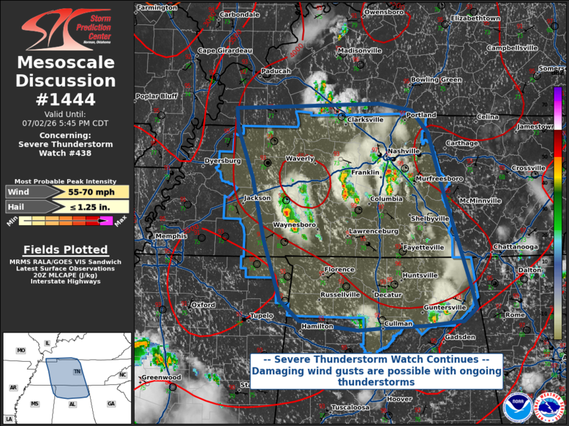
Mesoscale Discussion 1444 NWS Storm Prediction Center Norman OK 0338 PM CDT Thu Jul 02 2026 Areas affected...Middle Tennessee into northern Alabama Concerning...Severe Thunderstorm Watch 438... Valid 022038Z - 022245Z The severe weather threat for Severe Thunderstorm Watch 438 continues. SUMMARY...Severe Thunderstorm Watch 438 continues until 8 PM CDT. Storms in the watch area will be capable of damaging wind gusts of 55-70 MPH. DISCUSSION...As expected given the lack of upper-level flow, thunderstorms across Middle Tennessee and northern Alabama have been largely disorganized. However, given steep lapse rates, modest precipitable water content, and tall mixed-layer LCL heights near 2 km, wet microburst activity is possible with the strongest downdraft cores. These microbursts could be capable of damaging winds of 55-70 MPH. Since there is little in the way of convective organization, the expectation is that convective activity will diminish after sunset with the reduction in surface heating. ..Halbert.. 07/02/2026 ...Please see www.spc.noaa.gov for graphic product... ATTN...WFO...MRX...LMK...OHX...BMX...HUN...PAH...MEG... LAT...LON 36718890 36748797 36768688 36698641 36428619 35808599 35198578 34668561 34398552 34248570 34198624 34188675 34148717 34198762 34268801 34498828 35188851 35918868 36488888 36718890 MOST PROBABLE PEAK WIND GUST...55-70 MPH MOST PROBABLE PEAK HAIL SIZE...UP TO 1.25 IN |
|
|
Top/All Mesoscale Discussions/Forecast Products/Home |
|
Source link