| Mesoscale Discussion 1442 | |
| < Previous MD Next MD > | |

|
|
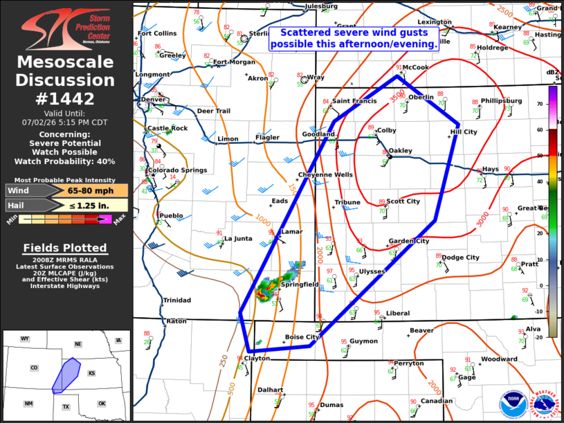
   Mesoscale Discussion 1442
   NWS Storm Prediction Center Norman OK
   0311 PM CDT Thu Jul 02 2026

   Areas affected...eastern Colorado and western Kansas.

   Concerning...Severe potential...Watch possible

   Valid 022011Z - 022215Z

   Probability of Watch Issuance...40 percent

   SUMMARY...Scattered severe wind gusts are possible this
   afternoon/evening.

   DISCUSSION...A supercell has developed on the Raton Mesa where SPC
   HRRR-based mesoanalysis shows minimal inhibition. Additional storms
   have started to develop farther northeast from this storm along the
   dryline into an increasingly unstable airmass. It is unclear whether
   these storms will continue to develop northeast along the boundary
   or if they will cluster and move into western Kansas, but either
   way, a region of greater severe wind threat may exits into western
   Kansas this afternoon/evening where 2500-3500 J/kg MLCAPE exists
   with mid-level flow of 25 to 30 knots, sufficient for some multicell
   storms. If sufficient clustering occurs this evening, a severe
   thunderstorm watch may need to be issued.

   ..Bentley/Hart.. 07/02/2026

   ...Please see www.spc.noaa.gov for graphic product...

   ATTN...WFO...DDC...GLD...AMA...PUB...ABQ...

   LAT...LON   37090324 39570173 40150068 39519967 38290009 36680212
               36600309 37090324

   MOST PROBABLE PEAK WIND GUST...65-80 MPH
   MOST PROBABLE PEAK HAIL SIZE...UP TO 1.25 IN
|
|
|
Top/All Mesoscale Discussions/Forecast Products/Home |
|
Source link