| Mesoscale Discussion 144 | |
| < Previous MD | |

|
|
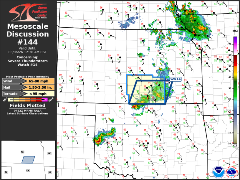
Mesoscale Discussion 0144 NWS Storm Prediction Center Norman OK 1055 PM CST Thu Mar 05 2026 Areas affected...South Central Kansas Concerning...Severe Thunderstorm Watch 14... Valid 060455Z - 060630Z The severe weather threat for Severe Thunderstorm Watch 14 continues. SUMMARY...Severe threat will increase across the southeastern half of ww014 over the next few hours. DISCUSSION...Long-lived supercell that developed over western OK earlier this evening has advanced into Grant county OK, and will soon cross the border into Sumner county KS. This supercell has a history of producing tornadoes. Latest surface data suggests the air mass just downstream of this storm is a bit cooler than across northern OK, but slow moistening is occurring across southern KS as the warm front gradually lifts north. VWP data at VNX and ICT exhibit very strong 0-3km SRH so this supercell should continue to track northeast, but some weakening is expected due to the aforementioned cooler boundary layer. Given the strength of the LLJ, a few thunderstorm clusters are expected to evolve across south central KS into the early morning hours. While some tornado risk exists with this storm as it tracks northeast, current thinking is hail/wind will become the primary concerns as updrafts should gradually decouple and become more elevated in nature. ..Darrow.. 03/06/2026 ...Please see www.spc.noaa.gov for graphic product... ATTN...WFO...TSA...ICT... LAT...LON 37949794 37949612 36999650 37019832 37949794 MOST PROBABLE PEAK TORNADO INTENSITY...UP TO 95 MPH MOST PROBABLE PEAK WIND GUST...65-80 MPH MOST PROBABLE PEAK HAIL SIZE...1.50-2.50 IN |
|
|
Top/All Mesoscale Discussions/Forecast Products/Home |
|
Source link