| Mesoscale Discussion 1439 | |
| < Previous MD | |

|
|
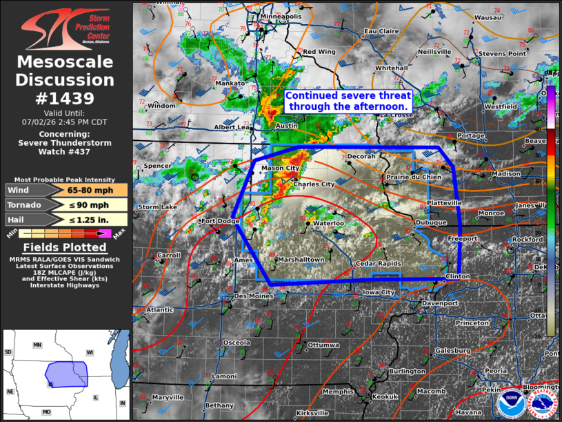
Mesoscale Discussion 1439 NWS Storm Prediction Center Norman OK 0110 PM CDT Thu Jul 02 2026 Areas affected...northeast Iowa and far southwest Wisconsin Concerning...Severe Thunderstorm Watch 437... Valid 021810Z - 021945Z The severe weather threat for Severe Thunderstorm Watch 437 continues. SUMMARY...The severe weather threat continues this afternoon across northeast Iowa. DISCUSSION...A cluster of storms has congealed across northern Iowa with a recent measured wind gust of 72 mph near Mason City, Iowa. Expect some southward preference of this cluster along the instability gradient through the afternoon. In addition, storms are starting to develop along the outflow boundary ahead of this cluster. These storms may also develop supercell characteristics considering 35 to 40 knots of mid-level flow sampled by the KARX VWP. These cells and the potential for further upscale growth as these storms congeal, will lead to an increasing damaging wind threat this afternoon across northeast Iowa and perhaps into far southwest Wisconsin. Easterly low-level flow north of the boundary and heating across this boundary could result in a narrow zone north of the outflow with some tornado potential. However, the low-level jet is quite weak (less than 20 knots below 2km per area VWPs) which would limit a greater threat. ..Bentley/Hart.. 07/02/2026 ...Please see www.spc.noaa.gov for graphic product... ATTN...WFO...MKX...DVN...ARX...DMX... LAT...LON 43299329 43469257 43469024 43219001 42508990 41878995 41869140 41809299 42619363 43299329 MOST PROBABLE PEAK TORNADO INTENSITY...UP TO 90 MPH MOST PROBABLE PEAK WIND GUST...65-80 MPH MOST PROBABLE PEAK HAIL SIZE...UP TO 1.25 IN |
|
|
Top/All Mesoscale Discussions/Forecast Products/Home |
|
Source link