| Mesoscale Discussion 1437 | |
| < Previous MD | |

|
|
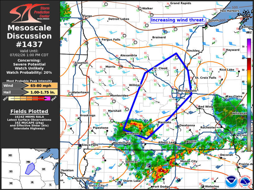
   Mesoscale Discussion 1437
   NWS Storm Prediction Center Norman OK
   1126 AM CDT Thu Jul 02 2026

   Areas affected...south-central into east-central Minnesota

   Concerning...Severe potential...Watch unlikely

   Valid 021626Z - 021800Z

   Probability of Watch Issuance...20 percent

   SUMMARY...A wind threat is increasing across southern Minnesota,
   east-central Minnesota, and far western Wisconsin into the early
   afternoon.

   DISCUSSION...A cluster of storms has developed on the nose of a
   500mb jet streak across southern Minnesota, driven by strong
   elevated instability (2000-3000 J/kg MUCAPE per SPC mesoanalysis).
   While this cluster does not look overly intense at this time, it
   does have some bowing element to it. The downstream environment
   remains unstable and some heating across central and east-central
   Minnesota may lead to increasing surface based instability.
   Therefore, this cluster may pose some wind threat as it moves
   northeast into the early afternoon.

   ..Bentley/Hart.. 07/02/2026

   ...Please see www.spc.noaa.gov for graphic product...

   ATTN...WFO...DLH...MPX...FSD...

   LAT...LON   43799435 44029520 45499444 46009329 45569286 44949274
               44349353 43799435

   MOST PROBABLE PEAK WIND GUST...65-80 MPH
   MOST PROBABLE PEAK HAIL SIZE...1.00-1.75 IN
|
|
|
Top/All Mesoscale Discussions/Forecast Products/Home |
|
Source link