| Mesoscale Discussion 1435 | |
| < Previous MD | |

|
|
Mesoscale Discussion 1435
NWS Storm Prediction Center Norman OK
0158 AM CDT Thu Jul 02 2026
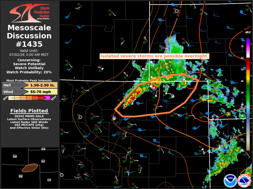
Areas affected...Northeast CO into the southern NE Panhandle
Concerning...Severe potential...Watch unlikely
Valid 020658Z - 020900Z
Probability of Watch Issuance...20 percent
SUMMARY...Isolated severe storms are possible overnight.
DISCUSSION...Strong to locally severe storms are ongoing across
parts of northeast CO as of 0655 UTC. Moist low-level easterly flow
beneath steep midlevel lapse rates is supporting moderate to locally
strong buoyancy, with objectively analyzed MUCAPE values ranging
from around 1000 J/kg north of Greeley to greater than 2000 J/kg
into far northeast CO. Veering wind profiles and modest
southwesterly flow aloft are resulting in effective shear of 30-40
kt, supportive of organized convection.
Strong multicells and perhaps a supercell or two will remain
possible through the early overnight, with a threat of large hail
and localized strong/severe gusts. Thus far, storms have been
relatively slow-moving, with a tendency toward some cell
interference. This trend may continue, resulting in a generally
isolated threat and making the need for a watch uncertain. However,
watch issuance may be considered if trends support a greater
coverage of severe threat overnight.
..Dean/Smith.. 07/02/2026
...Please see www.spc.noaa.gov for graphic product...
ATTN...WFO...LBF...BOU...CYS...
LAT...LON 40260520 40900444 41140346 41190292 41030238 40820248
40450284 40200335 40080453 40080494 40260520
MOST PROBABLE PEAK WIND GUST...55-70 MPH
MOST PROBABLE PEAK HAIL SIZE...1.50-2.50 IN
|
|
|
Top/All Mesoscale Discussions/Forecast Products/Home |
|
Source link