| Mesoscale Discussion 1432 | |
| < Previous MD | |

|
|
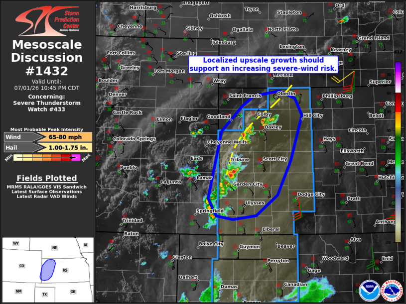
Mesoscale Discussion 1432 NWS Storm Prediction Center Norman OK 0843 PM CDT Wed Jul 01 2026 Areas affected...Portions of western Kansas Concerning...Severe Thunderstorm Watch 433... Valid 020143Z - 020345Z The severe weather threat for Severe Thunderstorm Watch 433 continues. SUMMARY...Upscale-growing thunderstorm clusters should promote an increasing risk of severe wind gusts over the next few hours -- within Severe Thunderstorm Watch 433. DISCUSSION...Earlier high-based thunderstorms are beginning to increase in coverage and intensity as they spread/develop northeastward along a NNE/SSW-oriented surface boundary in western KS. Here, richer boundary-layer moisture and steep midlevel lapse rates are contributing to strong surface-based buoyancy (per the 00Z DDC sounding). The GLD VWP is sampling around 45 kt of 0-6 km shear (likely weaker with southward extent), which combined with the strong buoyancy, should promote convective clustering and an increasing risk of severe wind gusts over the next few hours. ..Weinman.. 07/02/2026 ...Please see www.spc.noaa.gov for graphic product... ATTN...WFO...DDC...GLD...PUB... LAT...LON 37740228 39100195 39620142 39830112 39930044 39790002 39449985 38510014 37810049 37380104 37300164 37380207 37740228 MOST PROBABLE PEAK WIND GUST...65-80 MPH MOST PROBABLE PEAK HAIL SIZE...1.00-1.75 IN |
|
|
Top/All Mesoscale Discussions/Forecast Products/Home |
|
Source link