| Mesoscale Discussion 1430 | |
| < Previous MD Next MD > | |

|
|
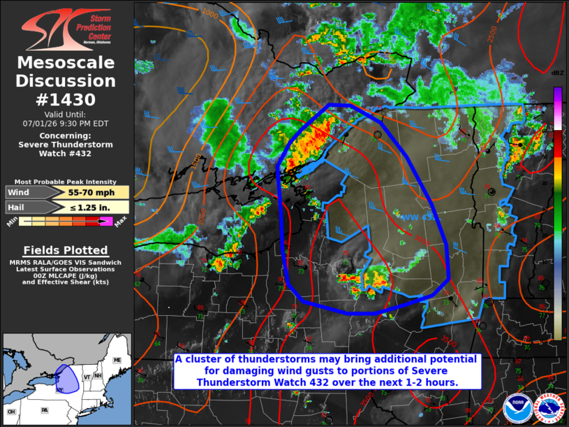
Mesoscale Discussion 1430 NWS Storm Prediction Center Norman OK 0707 PM CDT Wed Jul 01 2026 Areas affected...portions of north-central New York Concerning...Severe Thunderstorm Watch 432... Valid 020007Z - 020130Z The severe weather threat for Severe Thunderstorm Watch 432 continues. SUMMARY...A cluster of thunderstorms entering north-central New York may bring additional potential for occasionally damaging wind gusts. DISCUSSION...A cluster of thunderstorms has developed within a bullseye of locally greater buoyancy across portions of southern Ontario over the past couple of hours and is now progressing towards the St. Lawrence River and north-central New York. The exact evolution of this cluster remains uncertain as observations indicate greater low-level stability is in place immediately downstream to the east owing to prior convection. Greater buoyancy remains in place farther south, however, where convection has been more isolated and has not substantially stabilized the low-levels. The most likely scenario would be for this cluster to progress more southeastward along the surface theta-e gradient, with a gradual weakening of the northern edge and maintenance along the southern periphery. Regardless of the exact evolution, at least some potential for occasionally damaging wind gusts is likely to accompany this cluster over the next hour or two across north-central New York. ..Chalmers.. 07/02/2026 ...Please see www.spc.noaa.gov for graphic product... ATTN...WFO...BTV...ALY...BGM...BUF... LAT...LON 45027575 45017538 44817490 44427447 43867407 43377384 42977382 42797408 42687452 42587500 42577543 42727615 42917638 43337648 43757652 44307658 44587639 44727620 45027575 MOST PROBABLE PEAK WIND GUST...55-70 MPH MOST PROBABLE PEAK HAIL SIZE...UP TO 1.25 IN |
|
|
Top/All Mesoscale Discussions/Forecast Products/Home |
|
Source link