| Mesoscale Discussion 143 | |
| < Previous MD | |

|
|
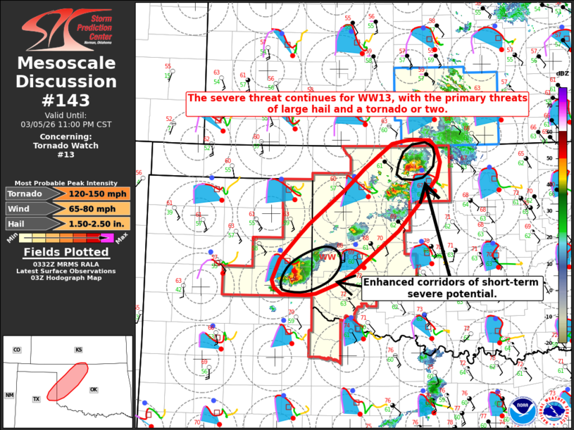
Mesoscale Discussion 0143 NWS Storm Prediction Center Norman OK 0934 PM CST Thu Mar 05 2026 Areas affected...portions of the eastern Texas Panhandle into northern Oklahoma and far southern Kansas Concerning...Tornado Watch 13... Valid 060334Z - 060500Z The severe weather threat for Tornado Watch 13 continues. SUMMARY...The severe threat continues across WW0013, with the primary threat for large hail and a tornado or two (perhaps strong). Two localized, short-term corridors of enhanced severe potential may accompany supercell thunderstorms currently tracking northeastward across portions of northern Oklahoma and the eastern Texas Panhandle. DISCUSSION...Regional VWP profiles depict strong low-level hodograph curvature, with over 300 m2/s2 0-500 m SRH, which will help support continued mesocyclone development and the potential for large hail and an isolated tornado or two with ongoing supercells across much of WW0013. The supercell thunderstorms currently tracking across portions of northern Oklahoma and the eastern Texas Panhandle are the primary concern for severe weather over the next 1-2 hours, with both supercells recently having confirmed tornadoes. In time, at least some decrease in severe potential is expected with the supercell in northern Oklahoma as it moves north/northeast and crosses the surface boundary into a more stable low-level air mass. MUCAPE values of 1500-2000 J/kg north of this boundary will allow the threat for large hail to persist for at least some time, however. ..Chalmers/Moore.. 03/06/2026 ...Please see www.spc.noaa.gov for graphic product... ATTN...WFO...ICT...OUN...DDC...AMA... LAT...LON 36529768 36189797 35729841 35129919 34949947 34789992 34760011 34760055 34860068 34970073 35290059 35660021 35810006 36369936 36659903 37029852 37079826 37089812 37089781 36969769 36759762 36529768 MOST PROBABLE PEAK TORNADO INTENSITY...120-150 MPH MOST PROBABLE PEAK WIND GUST...65-80 MPH MOST PROBABLE PEAK HAIL SIZE...1.50-2.50 IN |
|
|
Top/All Mesoscale Discussions/Forecast Products/Home |
|
Source link