| Mesoscale Discussion 1428 | |
| < Previous MD Next MD > | |

|
|
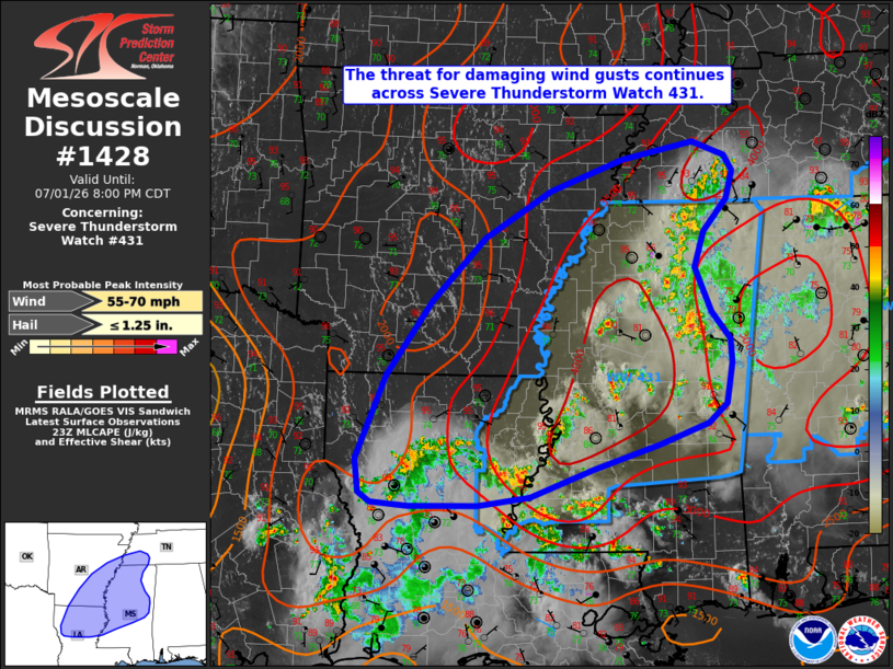
Mesoscale Discussion 1428 NWS Storm Prediction Center Norman OK 0605 PM CDT Wed Jul 01 2026 Areas affected...portions of the lower Mississippi River Valley Concerning...Severe Thunderstorm Watch 431... Valid 012305Z - 020100Z The severe weather threat for Severe Thunderstorm Watch 431 continues. SUMMARY...The threat for primarily damaging wind gusts continues across portions of Severe Thunderstorm Watch 431. DISCUSSION...Deep-layer easterly flow continues to support convective development along the western periphery of a consolidated cold pool across northwestern Mississippi, supporting the maintenance and westward propagation of an ongoing, loosely organized convective cluster that has produced several reports of damaging wind gusts over the past several hours. Expectation is for this activity to continue westward towards the Mississippi River though this evening. While the environment remains favorable for occasionally damaging downburst winds owing to strong buoyancy, steep low-level lapse rates, and high moisture content, gradual nocturnal low-level stabilization/cooling is expected to yield a gradual decrease in severe potential after 7-8 PM CDT. Farther southwest, a separate loosely organized cluster that previously developed across southern Louisiana continues to progress north-northwestward. Isolated damaging wind gusts may occur with this cluster, but the overall severe risk is anticipated to be lower owing to modestly weaker buoyancy across this area compared to farther northeast. ..Chalmers.. 07/01/2026 ...Please see www.spc.noaa.gov for graphic product... ATTN...WFO...MEG...JAN...LZK...LCH...SHV... LAT...LON 31659358 32049363 32999324 33859263 34589190 35119100 35479002 35688904 35518861 35338850 35028858 34648890 34238903 33728882 33428857 33148854 32688862 32458888 32218954 31939043 31619128 31529199 31509292 31549342 31659358 MOST PROBABLE PEAK WIND GUST...55-70 MPH MOST PROBABLE PEAK HAIL SIZE...UP TO 1.25 IN |
|
|
Top/All Mesoscale Discussions/Forecast Products/Home |
|
Source link