|
|
| Mesoscale Discussion 1427 | |
| < Previous MD | |

|
|
   Mesoscale Discussion 1427
   NWS Storm Prediction Center Norman OK
   1245 PM CDT Wed Jun 26 2024

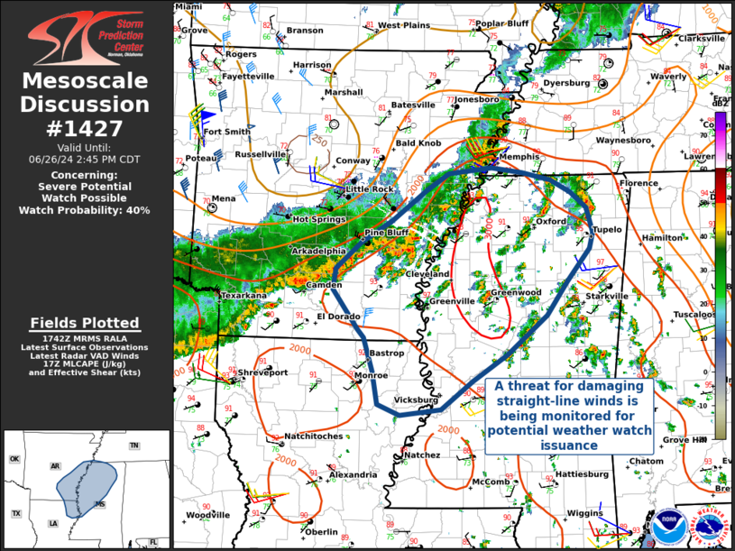
   Areas affected...Northeastern Louisiana into Southeast Arkansas and
   Northern Mississippi

   Concerning...Severe potential...Watch possible

   Valid 261745Z - 261945Z

   Probability of Watch Issuance...40 percent

   SUMMARY...A QLCS located near and along the Mississippi river, in
   addition to warm sector thunderstorms developing over much of
   Northern MS, are being monitored for possible weather watch
   issuance. The primary threat is for damaging straight-line winds.

   DISCUSSION...A QLCS located along and near the Mississippi River is
   advancing east-southeast into northern Mississippi, with another
   region of stronger reflectivity advancing from southern AR into
   northern LA. Ahead of the QLCS, warm sector thunderstorms have
   developed across much of MS and into western AL.

   This environment is characterized by MLCAPE > 2500 J/kg, but deep
   layer vertical shear remains weak at only 10-20 kts and mostly
   unidirectional. Coupled with anomalously high precipitable water
   values > 2 inches on the 12Z JAN sounding -- near the daily max for
   this time of year -- the primary severe threat appears to be from
   wet microbursts, in addition to damaging winds from QLCS outflow.

   Given current convective trends, the area is being monitored for
   weather watch issuance.

   ..Halbert/Weinman/Hart.. 06/26/2024

   ...Please see www.spc.noaa.gov for graphic product...

   ATTN...WFO...MEG...JAN...LZK...

   LAT...LON   33318934 32848991 32529040 32189086 32109144 32239176
               32639183 33039196 33149206 33629241 33869238 34199201
               34449157 34819106 35029074 35089013 35028969 34948928
               34798898 34598875 34298867 34118872 33718905 33318934
|
|
|
Top/All Mesoscale Discussions/Forecast Products/Home |
|


