| Mesoscale Discussion 1426 | |
| < Previous MD | |

|
|
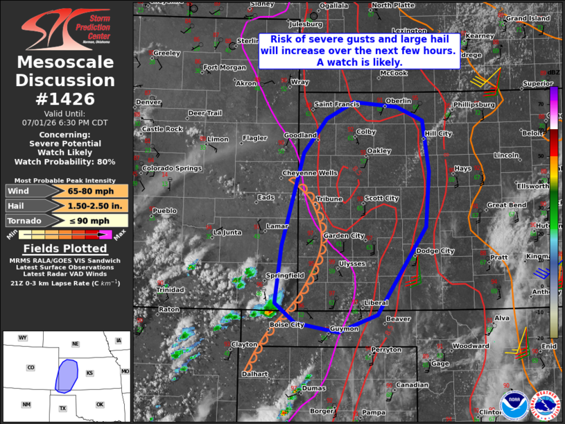
   Mesoscale Discussion 1426
   NWS Storm Prediction Center Norman OK
   0432 PM CDT Wed Jul 01 2026

   Areas affected...Parts of western KS...far southeastern CO...and the
   far northern OK Panhandle

   Concerning...Severe potential...Watch likely

   Valid 012132Z - 012330Z

   Probability of Watch Issuance...80 percent

   SUMMARY...The risk of severe wind gusts and isolated large hail will
   increase over the next few hours. A watch is likely.

   DISCUSSION...To the west of a north/south-oriented dryline in
   southwest KS, boundary-layer cumulus is deepening within the
   hot/well-mixed air over southeastern CO and northeastern NM. As a
   subtle midlevel impulse over northeastern NM (evident in water-vapor
   imagery) overspreads the area, widely scattered high-based
   thunderstorms should evolve east-northeastward into a moist,
   diurnally unstable air mass over western KS and vicinity. The DDC
   18Z sounding sampled steep deep-layer lapse rates, which will be
   favorable for the development of robust outflow with a mix of
   loosely organized clusters and some supercell structures (aided by
   around 30-40 kt of effective shear). While severe gusts will be the
   main concern, isolated large hail will also be possible with the
   more separated updrafts initially. Current thinking is that a watch
   will be needed.

   ..Weinman/Thompson.. 07/01/2026

   ...Please see www.spc.noaa.gov for graphic product...

   ATTN...WFO...DDC...GLD...AMA...PUB...

   LAT...LON   37880232 39170194 39640154 39770100 39680021 39449988
               38909974 38159980 37320035 36910108 36890198 37260235
               37880232

   MOST PROBABLE PEAK TORNADO INTENSITY...UP TO 90 MPH
   MOST PROBABLE PEAK WIND GUST...65-80 MPH
   MOST PROBABLE PEAK HAIL SIZE...1.50-2.50 IN
|
|
|
Top/All Mesoscale Discussions/Forecast Products/Home |
|
Source link