| Mesoscale Discussion 1425 | |
| < Previous MD | |

|
|
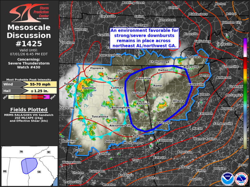
Mesoscale Discussion 1425 NWS Storm Prediction Center Norman OK 0352 PM CDT Wed Jul 01 2026 Areas affected...Northeast Alabama and northwest Georgia Concerning...Severe Thunderstorm Watch 430... Valid 012052Z - 012245Z The severe weather threat for Severe Thunderstorm Watch 430 continues. SUMMARY...An environment favorable for strong/severe downburst winds remains in place across portions of northeast Alabama and northwest Georgia. DISCUSSION...Over the past couple of hours, the highest concentration of thunderstorms has largely remained across north-central to northwest AL with an expanding cold pool noted in recent surface observations and RTMA analyses. To the east of this area, more isolated convection has largely left the environment across northeast AL into northwest GA largely intact with temperatures remaining in the mid 90s, low-level lapse rates near 8 C/km, and MLCAPE values between 3500-4000 J/kg. A thunderstorm cluster west of the Atlanta metro has recently demonstrated an uptick in intensity (per GOES IR imagery and lightning trends), which confirms that this environment remains favorable for robust deep convection. While it remains unclear exactly how widespread thunderstorm coverage will become through the evening hours, the potential for strong to severe downbursts and clustering/upscale growth remains across eastern portions of WW 430. ..Moore.. 07/01/2026 ...Please see www.spc.noaa.gov for graphic product... ATTN...WFO...FFC...BMX...HUN... LAT...LON 34938532 34988434 34868384 34258359 33708385 33348435 32898512 32818543 32898575 33048597 33488610 34188624 34468624 34668606 34818571 34938532 MOST PROBABLE PEAK WIND GUST...55-70 MPH MOST PROBABLE PEAK HAIL SIZE...UP TO 1.25 IN |
|
|
Top/All Mesoscale Discussions/Forecast Products/Home |
|
Source link