| Mesoscale Discussion 1408 | |
| < Previous MD Next MD > | |

|
|
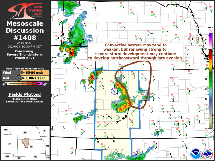
Mesoscale Discussion 1408 NWS Storm Prediction Center Norman OK 0833 PM CDT Tue Jun 30 2026 Areas affected...parts of northwestern into north central Kansas and adjacent southern Nebraska Concerning...Severe Thunderstorm Watch 425... Valid 010133Z - 010330Z The severe weather threat for Severe Thunderstorm Watch 425 continues. SUMMARY...The ongoing convective system may tend to weaken, but renewed strong to severe thunderstorm development might continue to develop into and northeast of Hill City and the Kansas/Nebraska state border vicinity through late evening. DISCUSSION...Notable low-level drying is ongoing across much of southern through eastern Kansas, as a remnant narrow plume of higher moisture content returns northwestward toward the Front Range through southern portions of the mid Missouri Valley, in advance of weak larger-scale mid-level troughing still digging into the West. It remains unclear how this will impact the ongoing convective cluster. However, the cold pool associated with this cluster is beginning to surge eastward out ahead of the stronger convection on its southern flank, to the north of Dodge City, and may tend to continue to propagate into the drier/substantively stabilizing environment. The MCV appears to be maintaining a north-northeastward migration toward the Hill City vicinity, and forcing for ascent to its northeast could support renewing vigorous thunderstorm within the southern fringe of the higher moisture content/strong potential instability across and north of the Kansas/Nebraska border into mid to late evening. ..Kerr.. 07/01/2026 ...Please see www.spc.noaa.gov for graphic product... ATTN...WFO...GID...DDC...GLD... LAT...LON 39740092 40210026 40299895 38519924 38409994 38620010 39150033 39740092 MOST PROBABLE PEAK WIND GUST...65-80 MPH MOST PROBABLE PEAK HAIL SIZE...1.00-1.75 IN |
|
|
Top/All Mesoscale Discussions/Forecast Products/Home |
|
Source link