|
|
| Mesoscale Discussion 1406 | |
| < Previous MD | |

|
|
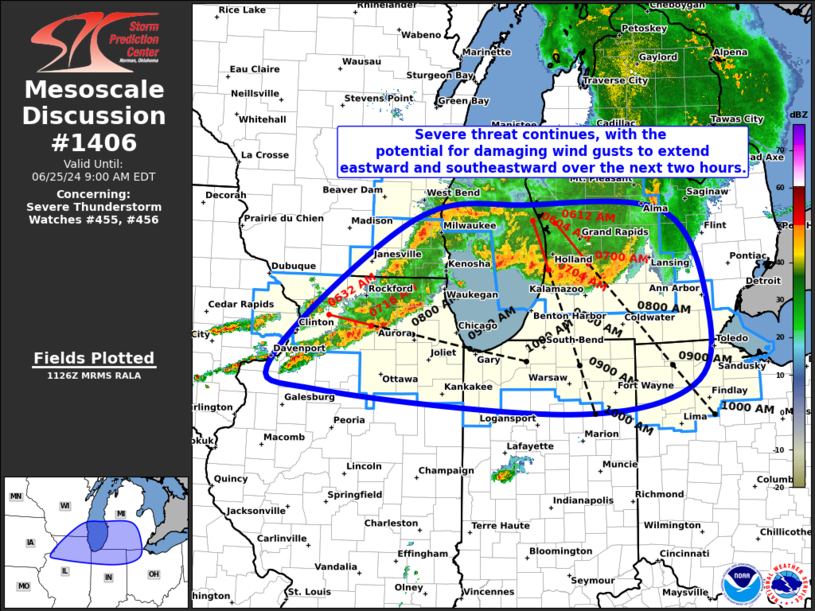
Mesoscale Discussion 1406 NWS Storm Prediction Center Norman OK 0628 AM CDT Tue Jun 25 2024 Areas affected...Far southeast WI...Southern Lower MI...Northern IL...Far Northern IN...Far Northwest OH Concerning...Severe Thunderstorm Watch 455...456... Valid 251128Z - 251300Z The severe weather threat for Severe Thunderstorm Watch 455, 456 continues. SUMMARY...Threat for damaging gusts will extend into more of southern Lower Michigan and adjacent northern Indiana and far northwest Ohio over the next two hours. Damaging wind gusts will also remain possible across far southeast Wisconsin and northern IL/Chicagoland. DISCUSSION...An organized MCS continues to push southeastward across central/southern Lake Michigan and southern Lower MI. Recent storm motion was estimated at 45 kt within the surging portion of the line near GRR, which is a bit slower than estimates two hours ago. Western portions of the MCS have trended slower and more southerly. Updrafts along the leading edge of the MCS are still quite strong, and the general expectation is for the threat for damaging gusts to persist for at least the next two hours as the system moves from southern Lower MI into northern IN and far northwest OH. Current storm motion brings the line into northern IN and far northwest OH around 1230Z. Farther west, thunderstorm coverage has increased across northern IL and far southeast WI, with the northern extent for this development now interacting with the outflow from the MCS. Some linear organization may be underway with these storms, supported by 40 to 50 kt mid-level flow and associated moderate deep-layer vertical shear. Storm motion is around 40 kt, bringing these storms into the Chicago area around 12 to 1230Z. Primary severe risk is damaging gusts. ..Mosier.. 06/25/2024 ...Please see www.spc.noaa.gov for graphic product... ATTN...WFO...CLE...DTX...IWX...GRR...LOT...ILX...MKX...DVN... LAT...LON 43188833 43378650 43268428 42148362 41208388 40878580 41128976 41499057 43188833 |
|
|
Top/All Mesoscale Discussions/Forecast Products/Home |
|


