| Mesoscale Discussion 1403 | |
| < Previous MD | |

|
|
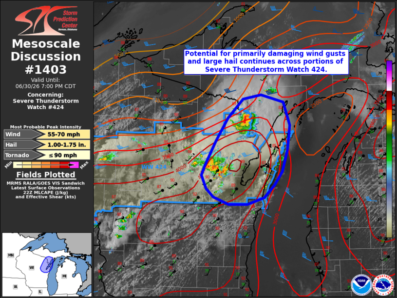
Mesoscale Discussion 1403 NWS Storm Prediction Center Norman OK 0533 PM CDT Tue Jun 30 2026 Areas affected...portions of eastern Wisconsin and the southern Upper Peninsula of Michigan Concerning...Severe Thunderstorm Watch 424... Valid 302233Z - 010000Z The severe weather threat for Severe Thunderstorm Watch 424 continues. SUMMARY...Potential for primarily damaging wind gusts and large hail continues across portions of Severe Thunderstorm Watch 424, including eastern Wisconsin and southern portions of the Michigan Upper Peninsula. DISCUSSION...Isolated to widely scattered convection has developed along a weak surface boundary across portions of central/eastern Wisconsin over the past 1-2 hours and has produced isolated reports of small hail and damaging wind gusts. While effective shear remains generally modest (25-35 kts) and low-to-mid level temperatures remain relatively warm across the region, strong to extreme buoyancy (4000-5000 J/kg per latest objective analysis) is expected to continue to support strong to severe thunderstorms across this region for another several hours. In the near-term, convection may tend to remain discrete/semi-discrete with a greater threat for large hail owing to modestly steep mid-level lapse rates (7-7.5 C/km). Some consolidation of cold pools over the next 1-2 hours may then foster upscale growth and a transition towards damaging wind gusts as the primary threat. ..Chalmers.. 06/30/2026 ...Please see www.spc.noaa.gov for graphic product... ATTN...WFO...MQT...GRB... LAT...LON 44538724 44338748 44218787 44218831 44338865 44488882 44698893 44868886 45268861 45648833 45948798 46028756 45898704 45528688 45108695 44768706 44538724 MOST PROBABLE PEAK TORNADO INTENSITY...UP TO 90 MPH MOST PROBABLE PEAK WIND GUST...55-70 MPH MOST PROBABLE PEAK HAIL SIZE...1.00-1.75 IN |
|
|
Top/All Mesoscale Discussions/Forecast Products/Home |
|
Source link