| Mesoscale Discussion 1402 | |
| < Previous MD | |

|
|
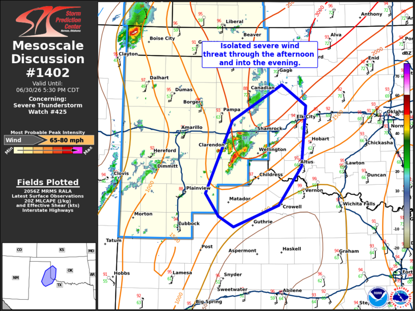
Mesoscale Discussion 1402 NWS Storm Prediction Center Norman OK 0358 PM CDT Tue Jun 30 2026 Areas affected...eastern Texas Panhandle...northwest Texas and western Oklahoma Concerning...Severe Thunderstorm Watch 425... Valid 302058Z - 302230Z The severe weather threat for Severe Thunderstorm Watch 425 continues. SUMMARY...Scattered severe wind threat will continue through the afternoon and into the evening. DISCUSSION...A cluster of storms have developed across the eastern Texas Panhandle within a hot airmass along a diffuse dryline. A 73 mph wind gust was reported on the Texas Mesonet near Lesley, Texas early in the lifecycle of the first storm. Weak shear across the area has led to an unorganized mode which should continue, however, the thermodynamic environment supports a damaging wind threat which may persist this afternoon and into the early evening. With satellite trends indicating additional development in the vicinity of this cluster, a scattered severe wind threat may continue for a few hours this evening. ..Bentley/Guyer.. 06/30/2026 ...Please see www.spc.noaa.gov for graphic product... ATTN...WFO...OUN...LUB...AMA... LAT...LON 34150128 35410073 36029971 35669921 34629930 33969977 33580070 33760102 34150128 MOST PROBABLE PEAK WIND GUST...65-80 MPH |
|
|
Top/All Mesoscale Discussions/Forecast Products/Home |
|
Source link