| Mesoscale Discussion 1401 | |
| < Previous MD | |
|
|
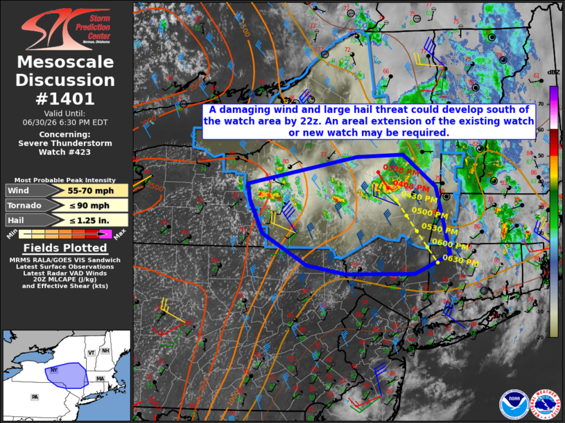
Mesoscale Discussion 1401 NWS Storm Prediction Center Norman OK 0332 PM CDT Tue Jun 30 2026 Areas affected...South-central and Southeast New York into Western Massachusetts and Northwest Connecticut Concerning...Severe Thunderstorm Watch 423... Valid 302032Z - 302230Z The severe weather threat for Severe Thunderstorm Watch 423 continues. SUMMARY...The threat for damaging winds and large hail continues across southern parts of the watch area. That threat may develop south of the current watch area by 22Z, requiring either an areal extension of the existing watch or a new downstream watch. DISCUSSION...Renewed thunderstorm development has recently occurred along the legacy cold pool across portions of Saratoga, Schenectady, and Montgomery Counties with more discrete storms persisting into Otsego County as of 20:20Z. A slight increase in inbound base velocities has been noted by the KENX radar, and given these trends, damaging wind potential may increase over the next hour with the re-strengthening bowing system. Assuming that scenario unfolds, the severe weather threat would potentially move out of the watch area by 22Z, requiring either a watch extension or new watch. ..Mead.. 06/30/2026 ...Please see www.spc.noaa.gov for graphic product... ATTN...WFO...OKX...ALY...BGM... LAT...LON 42647686 42877689 43257484 43297397 42847337 41907311 41627378 41637506 41757578 42197661 42647686 MOST PROBABLE PEAK TORNADO INTENSITY...UP TO 90 MPH MOST PROBABLE PEAK WIND GUST...55-70 MPH MOST PROBABLE PEAK HAIL SIZE...UP TO 1.25 IN |
|
|
Top/All Mesoscale Discussions/Forecast Products/Home |
|
Source link