| Mesoscale Discussion 1395 | |
| < Previous MD | |

|
|
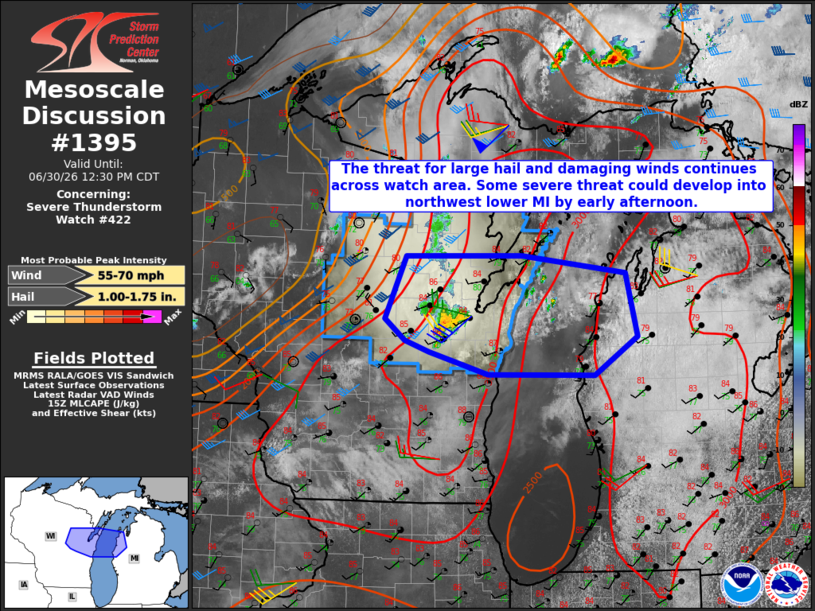
Mesoscale Discussion 1395 NWS Storm Prediction Center Norman OK 1034 AM CDT Tue Jun 30 2026 Areas affected...Northeast Wisconsin to Northwest Lower Michigan Concerning...Severe Thunderstorm Watch 422... Valid 301534Z - 301730Z The severe weather threat for Severe Thunderstorm Watch 422 continues. SUMMARY...Isolated occurrences of large hail and locally damaging wind gusts remain possible across mainly the southern half of Severe Thunderstorm Watch 422. Some remnant of the ongoing storms could move into parts of northwest lower Michigan by early afternoon and pose a severe weather threat. DISCUSSION...Trends in visible satellite and radar data indicate periodic intensification-weakening cycles with the storms ongoing west through southwest of Green Bay. The storms are moving through a moist and moderate to strongly unstable environment with MLCAPE as high as 3000-3500 J/kg, per latest objective analysis. The storm behavior thus far suggests they may still be slightly elevated and are not fully realizing the available buoyancy. The current KGRB VWP is sampling largely westerly tropospheric winds with 40-50 kt speeds noted above 5-6 km. The environment described above is supportive of storm organization, assuming updrafts can become rooted in the boundary layer. Large hail is the primary concern in the short term, but the potential for damaging winds may increase with time owing to the unidirectional wind profiles and potential for downshear propagation along an organizing cold pool. Some convection-allowing model guidance indicates the WI storms moving across Lake MI into northwest lower MI by early afternoon with an associated damaging wind threat. However, considerable cloudiness currently exists across lower MI this morning, which is slowing the destabilization process. ..Mead.. 06/30/2026 ...Please see www.spc.noaa.gov for graphic product... ATTN...WFO...APX...GRR...MQT...GRB...MKX... LAT...LON 44468939 45128908 45138734 44958580 44268563 43868626 43878785 44108872 44228909 44468939 MOST PROBABLE PEAK WIND GUST...55-70 MPH MOST PROBABLE PEAK HAIL SIZE...1.00-1.75 IN |
|
|
Top/All Mesoscale Discussions/Forecast Products/Home |
|
Source link