| Mesoscale Discussion 1393 | |
| < Previous MD | |

|
|
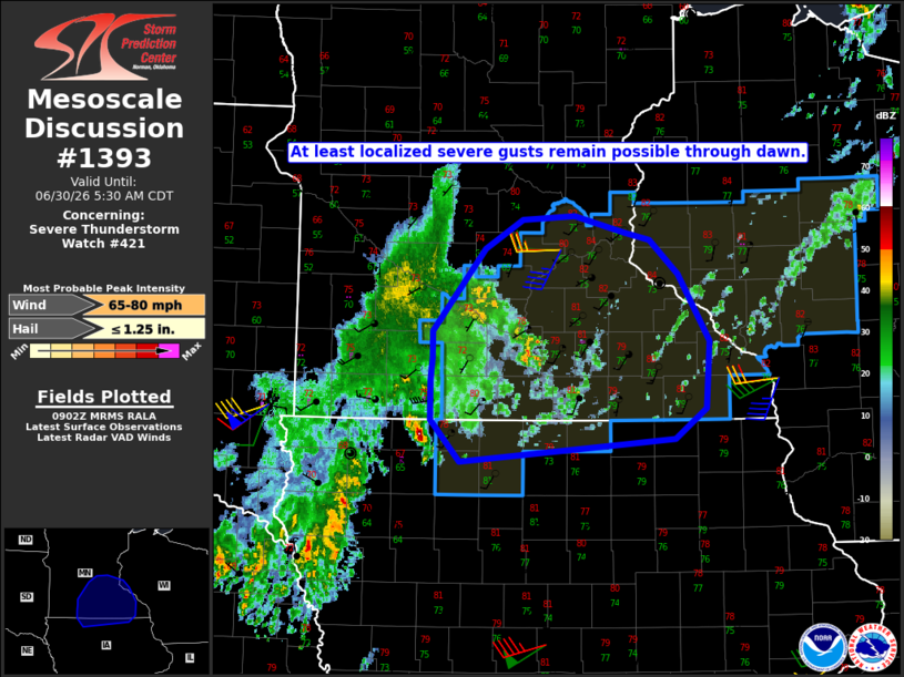
Mesoscale Discussion 1393 NWS Storm Prediction Center Norman OK 0404 AM CDT Tue Jun 30 2026 Areas affected...Southern MN into northern IA Concerning...Severe Thunderstorm Watch 421... Valid 300904Z - 301030Z The severe weather threat for Severe Thunderstorm Watch 421 continues. SUMMARY...At least localized severe gusts remain possible through dawn. DISCUSSION...Convection associated with a storm cluster over south-central MN has recently weakened, with CINH tending to weaken storms along the southern part of the cluster, and more stable conditions to the north of a frontal boundary constraining development within the northern part of the cluster. However, strong to severe gusts continue to be observed, most recently a 52 kt gust at KJYG in Watonwan County, MN. Downstream of this cluster, a more favorable environment remains in place into southeast MN and southwest WI, with MUCAPE of near/above 4000 J/kg and weaker CINH per recent objective mesoanalyses. Even if the ongoing cluster continues to weaken, some redevelopment and possible reorganization cannot be ruled out as the primary gust front/cold pool move into this environment. Some intensification of trailing convection across northwest IA also remains possible as it moves east-northeastward through the early morning. ..Dean.. 06/30/2026 ...Please see www.spc.noaa.gov for graphic product... ATTN...WFO...ARX...MPX...DMX...FSD... LAT...LON 44209496 44209496 44859439 45089397 45109341 44989286 44919259 44659227 44129194 43599197 43359231 43309288 43179465 43509497 43809498 43999496 44209496 MOST PROBABLE PEAK WIND GUST...65-80 MPH MOST PROBABLE PEAK HAIL SIZE...UP TO 1.25 IN |
|
|
Top/All Mesoscale Discussions/Forecast Products/Home |
|
Source link