| Mesoscale Discussion 1391 | |
| < Previous MD | |

|
|
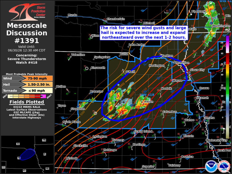
Mesoscale Discussion 1391 NWS Storm Prediction Center Norman OK 1025 PM CDT Mon Jun 29 2026 Areas affected...portions of central and northeastern Nebraska Concerning...Severe Thunderstorm Watch 418... Valid 300325Z - 300530Z The severe weather threat for Severe Thunderstorm Watch 418 continues. SUMMARY...The potential for severe wind gusts (potentially including significant gusts up to 75-90 mph) and large hail is expected to expand northeastward over the next 1-2 hours. DISCUSSION...Ongoing convection across Severe Thunderstorm Watch 218 has been slow to develop/organize thus far, but an uptick in convective intensity has recently been noted across central Nebraska over the past 30-60 minutes. This activity is occurring along the northern periphery of a surface instability/theta-e gradient and at the northern tip of a strengthening southerly, low-level jet sampled by the UEX VWP. While latest high-res model guidance has somewhat struggled with the overall placement of convection, guidance continues to suggest that upscale growth into a compact, bowing cluster/complex will occur as convection evolves (and potentially accelerates northeastward) along the aforementioned gradient. While uncertainty remains regarding the exact convective evolution over the next 1-2 hours owing to the complexity of cell/convective interactions, strong to extreme instability (MLCAPE of 4000-5000 J/kg indicated by latest objective analysis and the 00z OAX observed sounding) along and southeast of this gradient coupled with strong effective shear (50-60+ kts) and steep mid-level lapse rates would favor an increasing severe threat in this scenario. Severe to significant wind gusts up to 75-90 mph (perhaps locally greater in a higher-end scenario) remain conditionally plausible pending the organization of ongoing convection into an organized cluster. Large hail also remains possible with any semi-discrete or embedded supercell structures, with additional potential for wind-driven hail to accompany any stronger cluster. ..Chalmers.. 06/30/2026 ...Please see www.spc.noaa.gov for graphic product... ATTN...WFO...FSD...OAX...GID...LBF... LAT...LON 41239886 41269914 41409943 41659942 41939927 42389866 42649826 42769802 42889768 42919723 42779671 42579656 42309649 42089666 41899692 41629743 41389811 41239886 MOST PROBABLE PEAK TORNADO INTENSITY...UP TO 90 MPH MOST PROBABLE PEAK WIND GUST...75-90 MPH MOST PROBABLE PEAK HAIL SIZE...1.50-2.50 IN |
|
|
Top/All Mesoscale Discussions/Forecast Products/Home |
|
Source link