| Mesoscale Discussion 1390 | |
| < Previous MD Next MD > | |

|
|
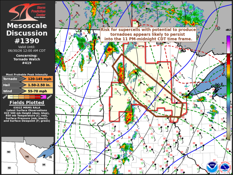
Mesoscale Discussion 1390 NWS Storm Prediction Center Norman OK 1004 PM CDT Mon Jun 29 2026 Areas affected...parts of north central into northeastern Minnesota Concerning...Tornado Watch 419... Valid 300304Z - 300500Z The severe weather threat for Tornado Watch 419 continues. SUMMARY...The risk for evolving supercells with potential to produce tornadoes will continue at least another couple of hours, into and through the 11 PM-midnight CDT time frame. DISCUSSION...A short wave perturbation now rapidly pivoting north-northeastward through the Dakotas is forecast to be accompanied by veering mid-level flow and northeastward progression of mid-level cooling across the remainder of north central through northeastern Minnesota during the next few hours. It appears that this will outpace the northeastward retreat of a remnant outflow boundary/warm front, which the latest Rapid Refresh suggests will weaken into the overnight hours. It is not clear that forcing for ascent associated with warm advection along this boundary will be strong enough, and/or through a deep enough layer, to support a substantive upscale growing cluster. However, as convective development remains largely discrete, the high boundary-layer moisture content and potential near-surface buoyancy along the boundary, could still support the risk for tornadoes in evolving supercells for at least a couple more hours, before veering flow in lower-levels leads to less conducive low-level hodographs. ..Kerr.. 06/30/2026 ...Please see www.spc.noaa.gov for graphic product... ATTN...WFO...DLH...MPX...FGF... LAT...LON 48169568 47419425 46389249 45909261 45939386 46579498 47729615 48169568 MOST PROBABLE PEAK TORNADO INTENSITY...120-145 MPH MOST PROBABLE PEAK WIND GUST...55-70 MPH MOST PROBABLE PEAK HAIL SIZE...1.50-2.50 IN |
|
|
Top/All Mesoscale Discussions/Forecast Products/Home |
|
Source link