| Mesoscale Discussion 1389 | |
| < Previous MD | |

|
|
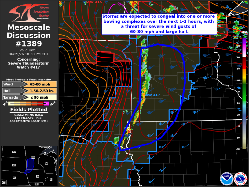
Mesoscale Discussion 1389 NWS Storm Prediction Center Norman OK 0859 PM CDT Mon Jun 29 2026 Areas affected...portions of southeastern South Dakota into northwestern Iowa and southwestern Minnesota Concerning...Severe Thunderstorm Watch 417... Valid 300159Z - 300330Z The severe weather threat for Severe Thunderstorm Watch 417 continues. SUMMARY...Developing thunderstorms will continue to grow upscale over the next 1-2 hours with a transition towards severe wind gusts of 60-80 mph as the primary threat. Large hail also remains possible. DISCUSSION...Thunderstorm coverage has gradually increased along an eastward-progressing cold front across portions of eastern South Dakota and western Minnesota over the past hour. As this development continues, rapid upscale growth into one or more bowing complexes is anticipated over the next 1-2 hours. Aided by strong to extreme instability and steep mid-level lapse rates (5000-6000 J/kg MLCAPE and 9+ C/km, respectively, indicated by latest objective analysis and sampled by regional 00z observed soundings), rich boundary layer moisture, and strong effective shear of 50-60 kts, this transition to a more linear mode will favor an increase in the risk for severe wind gusts of 60-80 mph as convection evolves eastward. Large to very large hail to 2" in diameter also remains possible, particularly with any supercells that can remain semi-discrete. ..Chalmers.. 06/30/2026 ...Please see www.spc.noaa.gov for graphic product... ATTN...WFO...MPX...DMX...FSD...ABR... LAT...LON 42769694 43249668 44119608 44759607 44829606 45249610 45529607 45709604 45759575 45839533 45799485 45709457 45549430 45269418 44719415 44069430 43549458 42999518 42829564 42599685 42769694 MOST PROBABLE PEAK TORNADO INTENSITY...UP TO 90 MPH MOST PROBABLE PEAK WIND GUST...65-80 MPH MOST PROBABLE PEAK HAIL SIZE...1.50-2.50 IN |
|
|
Top/All Mesoscale Discussions/Forecast Products/Home |
|
Source link