| Mesoscale Discussion 1387 | |
| < Previous MD Next MD > | |

|
|
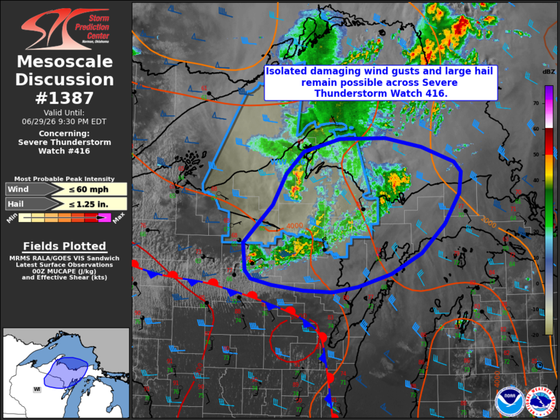
Mesoscale Discussion 1387 NWS Storm Prediction Center Norman OK 0703 PM CDT Mon Jun 29 2026 Areas affected...portions of northern Wisconsin and the Michigan Upper Peninsula Concerning...Severe Thunderstorm Watch 416... Valid 300003Z - 300130Z The severe weather threat for Severe Thunderstorm Watch 416 continues. SUMMARY...Isolated damaging wind gusts and large hail remain possible across Severe Thunderstorm Watch 416. DISCUSSION...Ongoing convection across Severe Thunderstorm Watch 416 has appeared to undergo gradual weakening over the past 1-2 hours (likely due to increased MUCIN), with generally warming cloud tops and weakening reflectivity cores noted on satellite and radar imagery, respectively. This suggests that the overall severe risk has decreased, which is supported by the concurrent decrease in observed wind/hail reports over the same time span. While the general expectation is for the severe threat to continue to decrease across this region, continued lower tropospheric warm air advection atop a surface stationary boundary may continue to support some potential for convective maintenance/redevelopment, particularly on the southern flank of the remnant MCS. While this scenario remains somewhat uncertain, moderately strong effective shear and steep mid-level lapse rates will conditionally continue to support a risk for isolated large hail with any stronger convection that can become sustained. Occasional damaging wind gusts also remain possible given the lingering influence of the MCS rear inflow jet (40-45 kts sampled at around 1000 kft AGL by KMQT) and the potential for isolated, stronger downdrafts to penetrate the near-surface stable layer and transport this momentum downward. ..Chalmers.. 06/30/2026 ...Please see www.spc.noaa.gov for graphic product... ATTN...WFO...APX...MQT...GRB... LAT...LON 46408909 46818885 47108851 47268783 47288696 47158627 46968566 46828553 46548557 46148584 45778629 45508686 45328749 45258796 45278851 45348911 45438949 45538960 45908965 46408909 MOST PROBABLE PEAK WIND GUST...UP TO 60 MPH MOST PROBABLE PEAK HAIL SIZE...UP TO 1.25 IN |
|
|
Top/All Mesoscale Discussions/Forecast Products/Home |
|
Source link