| Mesoscale Discussion 1384 | |
| < Previous MD | |

|
|
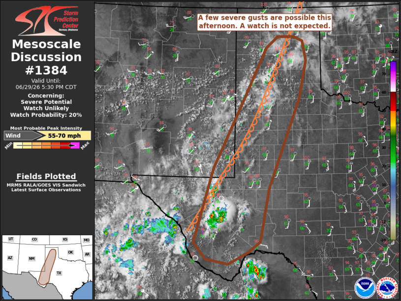
   Mesoscale Discussion 1384
   NWS Storm Prediction Center Norman OK
   0337 PM CDT Mon Jun 29 2026

   Areas affected...portions of western texas and far southeastern New
   Mexico

   Concerning...Severe potential...Watch unlikely

   Valid 292037Z - 292230Z

   Probability of Watch Issuance...20 percent

   SUMMARY...A few severe gusts are possible across portions of western
   Texas and far southeastern New Mexico this afternoon and evening. A
   watch is not anticipated.

   DISCUSSION...Thunderstorms are developing along the terrain of west
   Texas, and cumulus is deepening along a diffuse dryline across
   portions of far southeastern new Mexico and the Texas Panhandle.
   These storms are well south of the main mid-level jet axis, and the
   18Z MAF RAOB showed relatively modest flow throughout the column. A
   relatively dry boundary layer with steep lapse rates is also
   apparent in short-term RAP forecast profiles, and this may provide a
   risk for severe gusts across portions of west Texas and far
   southeastern New Mexico. With the relatively weak deep-layer shear,
   some clustering of storms may occur, and this would increase the
   risk of severe gusts. However, this activity is still expected to
   remain sparse in coverage, and therefore, a watch is not anticipated
   at this time.

   ..Supinie/Guyer.. 06/29/2026

   ...Please see www.spc.noaa.gov for graphic product...

   ATTN...WFO...SJT...LUB...AMA...MAF...ABQ...

   LAT...LON   32260378 34050286 35820194 36150152 36150095 36010065
               35430052 34310079 31660187 30110217 29790260 29460326
               29600403 30080445 32260378

   MOST PROBABLE PEAK WIND GUST...55-70 MPH
|
|
|
Top/All Mesoscale Discussions/Forecast Products/Home |
|
Source link