| Mesoscale Discussion 1382 | |
| < Previous MD | |

|
|
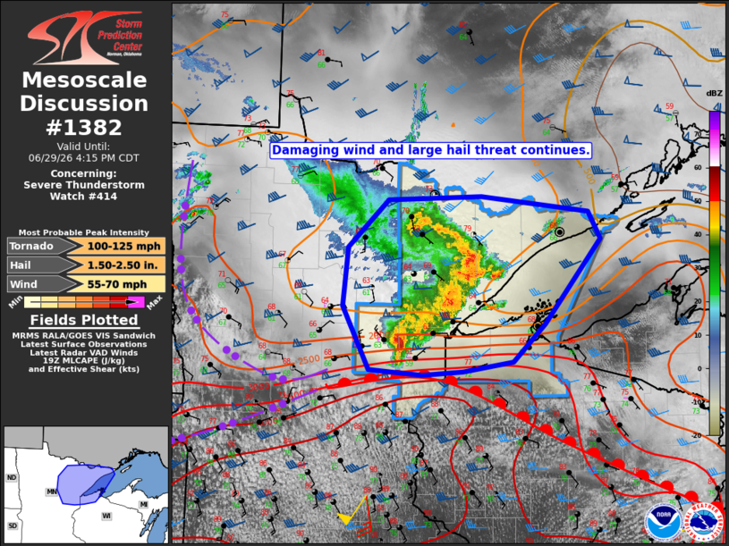
Mesoscale Discussion 1382 NWS Storm Prediction Center Norman OK 0214 PM CDT Mon Jun 29 2026 Areas affected...Northeast Minnesota...including the Arrowhead Concerning...Severe Thunderstorm Watch 414... Valid 291914Z - 292115Z The severe weather threat for Severe Thunderstorm Watch 414 continues. SUMMARY...The threat for damaging winds and large hail is expected to continue across remaining valid portions of Severe Thunderstorm Watch #414. The greatest potential for a tornado or two exists with a supercell on the southern end of the bowing MCS in the vicinity of the warm front. DISCUSSION...As of 19Z, KDLH radar data indicated a well-defined bow echo across St. Louis County with a trailing supercell over Aitkin County. Movement of the bow echo was to the northeast at 50 kt. Sporadic wind damage reports and marginally severe wind gusts have occurred over the past hour, despite earlier volumetric radar data sampling an 80+ kt rear-inflow jet (RIJ). Relatively cool and stable near-ground conditions are likely inhibiting the majority of higher-momentum flow in the RIJ from reaching the surface, except where locally intense downbursts are able to penetrate the stable layer. Expect that trend to continue with the bow echo as the low-level stability will likely be maintained by onshore flow from off Lake Superior. Meanwhile, the supercell over Aitkin County recently produced hail up to 1.5 inches, and its likely large hail potential will continue with that storm as it continues east along the immediate cool side of the warm front. That threat is expected to spread east into far northwest WI, where the watch has been locally extended. In addition to the hail threat, the potential exists for a tornado or two owing to the proximity of the warm front where low-level shear is maximized. That threat is conditional on the supercell being firmly rooted with the boundary layer. ..Mead.. 06/29/2026 ...Please see www.spc.noaa.gov for graphic product... ATTN...WFO...DLH... LAT...LON 46269199 46229268 46279356 46999399 47669391 48209324 48259169 48078990 47758969 46799063 46369116 46269199 MOST PROBABLE PEAK TORNADO INTENSITY...100-125 MPH MOST PROBABLE PEAK WIND GUST...55-70 MPH MOST PROBABLE PEAK HAIL SIZE...1.50-2.50 IN |
|
|
Top/All Mesoscale Discussions/Forecast Products/Home |
|
Source link