|
|
| Mesoscale Discussion 1380 | |
| < Previous MD | |

|
|
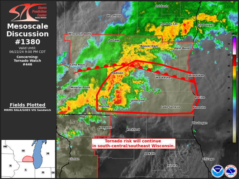
Mesoscale Discussion 1380 NWS Storm Prediction Center Norman OK 0729 PM CDT Sat Jun 22 2024 Areas affected...Portions of southern Wisconsin Concerning...Tornado Watch 446... Valid 230029Z - 230200Z The severe weather threat for Tornado Watch 446 continues. SUMMARY...Tornadoes remain possible with remaining discrete and line-embedded supercells this evening. Local extension in time of WW 446 will likely be needed. DISCUSSION...A line of thunderstorms, with embedded supercells continues eastward through south-central Wisconsin. One embedded supercell produced a radar confirmed tornado just southeast of the town of Marshall. On the Green/Rock County border, a more discrete supercell is also moving east. The KMXK VAD shows large low-level SRH values. The environment just south of the warm front will remain favorable for tornadoes as this activity moves eastward toward Milwaukee this evening. ..Wendt.. 06/23/2024 ...Please see www.spc.noaa.gov for graphic product... ATTN...WFO...MKX... LAT...LON 42558965 42788965 42928955 43108937 43288891 43238845 43088780 42708769 42528783 42518840 42558965 |
|
|
Top/All Mesoscale Discussions/Forecast Products/Home |
|