| Mesoscale Discussion 1377 | |
| < Previous MD | |

|
|
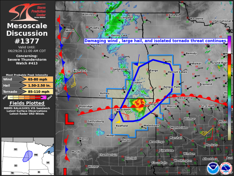
Mesoscale Discussion 1377 NWS Storm Prediction Center Norman OK 0906 AM CDT Mon Jun 29 2026 Areas affected...Northeast South Dakota...Southeast North Dakota...and West-central Minnesota Concerning...Severe Thunderstorm Watch 413... Valid 291406Z - 291600Z The severe weather threat for Severe Thunderstorm Watch 413 continues. SUMMARY...The threat for damaging winds with gusts of 60-80 mph, large hail, and perhaps a couple of tornadoes is expected to continue with ongoing bow echo. DISCUSSION...As of 14Z, the KABR radar indicated a compact but intense bow echo over Marshall, Day, and Roberts Counties in northeast SD, moving northeast at 45 kt. A couple of tornadoes have recently been reported with meso-vortices forming near the apex of the bow. Mesoanalysis places the convective system very near a warm front lifting north through the region, where a corridor of enhanced low-level shear likely resides. Latest short-term model guidance suggests that the bow echo will continue northeast into west-central/northwest MN this morning with extrapolation of the current motion taking it to the edge of Severe Thunderstorm Watch #413 between 1530 and 16Z (10:30-11:00 AM CDT). Latest mesoanalysis indicates a reservoir of moderate to strong instability (MLCAPE of 2000-4000 J/kg) in the vicinity of and immediately downstream of the bow echo, which will continue to fuel vigorous up/downdrafts with an attendant threat for severe wind gusts in the 60-80 mph range and large hail up to golf-ball size. Tornado potential will be contingent on the warm front lifting north at a similar speed of the bow echo, allowing it to reside within a zone of stronger low-level shear. ..Mead.. 06/29/2026 ...Please see www.spc.noaa.gov for graphic product... ATTN...WFO...MPX...FGF...ABR...BIS... LAT...LON 45479832 46339775 47069732 47339659 47169571 46809552 46199562 45499661 45179727 45119760 45109811 45479832 MOST PROBABLE PEAK TORNADO INTENSITY...85-110 MPH MOST PROBABLE PEAK WIND GUST...65-80 MPH MOST PROBABLE PEAK HAIL SIZE...1.50-2.50 IN |
|
|
Top/All Mesoscale Discussions/Forecast Products/Home |
|
Source link