| Mesoscale Discussion 1376 | |
| < Previous MD | |

|
|
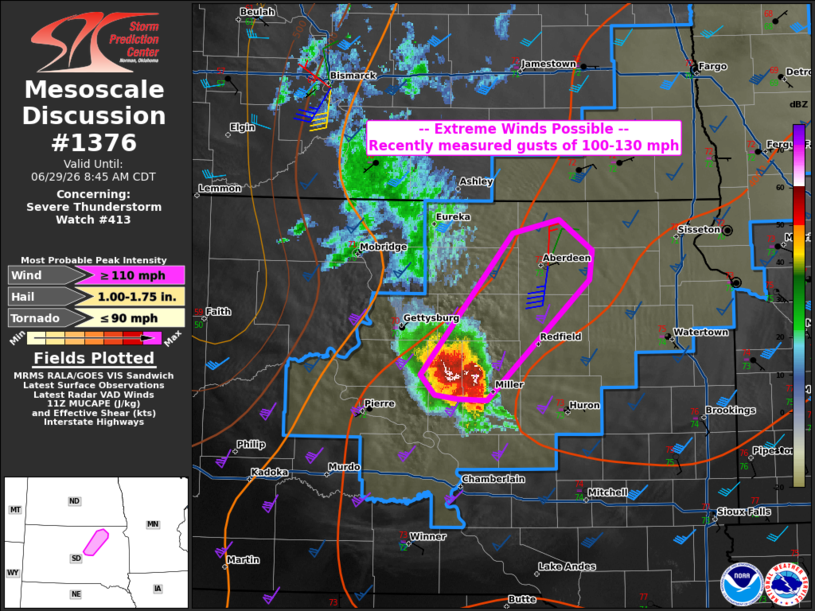
Mesoscale Discussion 1376 NWS Storm Prediction Center Norman OK 0640 AM CDT Mon Jun 29 2026 Areas affected...east-central into northeast South dakota Concerning...Severe Thunderstorm Watch 413... Valid 291140Z - 291345Z The severe weather threat for Severe Thunderstorm Watch 413 continues. SUMMARY...A corridor of extreme tornado-like wind damage may persist for an hour or two into northeast South Dakota. DISCUSSION...A storm complex continues to travel quickly northeastward out of central SD. This complex has supercell characteristics, but is extremely large. Measured winds up to 131 mph have occurred, with multiple 100+ mph gusts also measured. Though presumably straight-line winds, these speeds are firmly within the EF2 range. Given the longevity of this storm complex, similar wind speeds, at least 80 to 100 mph, appear likely to approach the Aberdeen SD area later this morning. ..Jewell.. 06/29/2026 ...Please see www.spc.noaa.gov for graphic product... ATTN...WFO...ABR... LAT...LON 44639974 45699878 45809828 45579793 45359796 44459905 44469935 44489959 44639974 MOST PROBABLE PEAK TORNADO INTENSITY...UP TO 90 MPH MOST PROBABLE PEAK WIND GUST...110+ MPH MOST PROBABLE PEAK HAIL SIZE...1.00-1.75 IN |
|
|
Top/All Mesoscale Discussions/Forecast Products/Home |
|
Source link