| Mesoscale Discussion 1374 | |
| < Previous MD | |

|
|
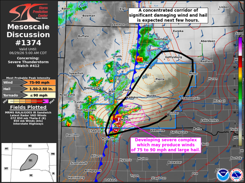
Mesoscale Discussion 1374 NWS Storm Prediction Center Norman OK 0302 AM CDT Mon Jun 29 2026 Areas affected...much of central South Dakota Concerning...Severe Thunderstorm Watch 412... Valid 290802Z - 291000Z The severe weather threat for Severe Thunderstorm Watch 412 continues. SUMMARY...Storms over south-central South Dakota are expected to become an intense complex over the next couple hours, producing winds of 75-90 mph and large hail across central parts of the state. DISCUSSION...Earlier supercells have merged near the cold front and surface low over southwest SD, with recent radar trends indicating the early stages of upscale growth into a compact but significantly severe MCS. Aside from the supercell over Bennett County SD, radar also shows a warm advection wing developing east/northeast of it, with additional development south of this cell along the cold front. This evolution is taking place near a substantial 850 mb theta-e gradient, with MUCAPE up to 4000 J/kg along and south of the surge. Given recent trends, strong instability and steep lapse rates aloft, and a favorable low-level jet, confidence is increasing that this complex will strengthen, and possible accelerate northeastward through the morning hours. Additional watches may be required downstream into more of northern/northeast SD and southeast ND as the scenario evolves. ..Jewell.. 06/29/2026 ...Please see www.spc.noaa.gov for graphic product... ATTN...WFO...FSD...ABR...LBF...UNR... LAT...LON 42900231 43320213 43610187 44000134 44560086 45220005 45179925 44989881 44579880 43819925 43180022 42920144 42760224 42900231 MOST PROBABLE PEAK TORNADO INTENSITY...UP TO 90 MPH MOST PROBABLE PEAK WIND GUST...75-90 MPH MOST PROBABLE PEAK HAIL SIZE...1.50-2.50 IN |
|
|
Top/All Mesoscale Discussions/Forecast Products/Home |
|
Source link