|
|
| Mesoscale Discussion 1373 | |
| < Previous MD | |

|
|
   Mesoscale Discussion 1373
   NWS Storm Prediction Center Norman OK
   0251 PM CDT Sat Jun 22 2024

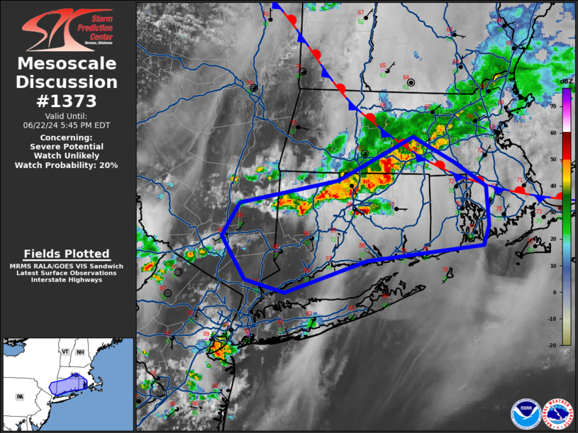
   Areas affected...Southeast NY...CT...RI...central MA

   Concerning...Severe potential...Watch unlikely

   Valid 221951Z - 222145Z

   Probability of Watch Issuance...20 percent

   SUMMARY...The potential for widely scattered 50-65 mph gusts capable
   of wind damage will maximize and become focused over a mesoscale
   area over the next 2-3 hours (mainly prior to 23 UTC/7 pm EDT).
   Because of the small spatiotemporal window of the severe risk area,
   a severe thunderstorm watch is unlikely.

   DISCUSSION...An organized linear band of strong to severe
   thunderstorms will likely continue to move east-southeastward to the
   southern New England coast over the next several hours.  Echo top
   trends over the past 2 hours has shown tops increase from 40 kft to
   50 kft.  This convective trend is an indication that 1500-2000 J/kg
   MLCAPE (buoyancy) has become realized by the stronger storms over
   CT.  The moderately strong westerly 2-6 km flow (30 kt) will support
   updraft/cold pool organization as this activity moves through a very
   moist airmass (low to mid 70s surface dewpoints).  Brief/transient
   rotation with updrafts encountering relatively backed flow
   (south-southeasterly at the surface) may aid in mesoscyclonic
   rotation and perhaps hail potential (1 to 1.5 inches in diameter)
   with discrete storms ahead of the line.  Otherwise, wind damage
   potential due to strong-severe gusts (50-65 mph) will be the primary
   risk with the stronger storms.

   ..Smith/Hart.. 06/22/2024

   ...Please see www.spc.noaa.gov for graphic product...

   ATTN...WFO...BOX...OKX...ALY...

   LAT...LON   41287250 41017342 41137388 41497413 41787393 41967282
               42347197 42117151 41917115 41587113 41427118 41287250
|
|
|
Top/All Mesoscale Discussions/Forecast Products/Home |
|


