|
|
| Mesoscale Discussion 1371 | |
| < Previous MD | |

|
|
   Mesoscale Discussion 1371
   NWS Storm Prediction Center Norman OK
   1111 AM CDT Sat Jun 22 2024

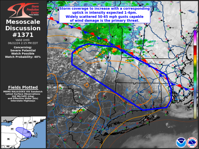
   Areas affected...central into eastern NY...CT...RI...western and
   central MA

   Concerning...Severe potential...Watch possible

   Valid 221611Z - 221815Z

   Probability of Watch Issuance...40 percent

   SUMMARY...Storm coverage to increase with a corresponding uptick in
   intensity expected 1-4pm EDT (17-20 UTC).  Widely scattered 50-65
   mph gusts capable of wind damage will be the primary threat.
   Marginally severe hail (0.75 to 1.25 inches in diameter) may occur
   with the strongest cell.  An upgrade to Slight Risk is forthcoming
   in the 1630 UTC Day 1 Convective Outlook.

   DISCUSSION...The 12 UTC (8am EDT) Albany, NY raob showed a very
   moist profile with PW 1.94 inches and weak lapse rates.  Around 500
   J/kg MLCAPE was noted in this observed sounding.  Visible-satellite
   imagery shows an agitated cumulus field over central and eastern NY
   to the south of a few ongoing thunderstorms.  A stratus deck is
   observed over the eastern half of MA into RI, and this stratus
   loosely corresponds with the placement of a west-northwest to
   east-southeast oriented stationary front.  Additional heating since
   this morning's raob at Albany (1000-1500 J/kg MLCAPE likely at
   midday) has contributed to a destabilizing airmass from central NY
   east-southeast into CT to the south of the stationary front.

   Of particular note compared to yesterday, slightly stronger 1-6 km
   westerly flow (20-35 kt) is observed at the WSR-88D KENX VAD
   (Albany).  This slight enhancement to westerly flow coupled with
   MLCAPE rising into the 1500-2000 J/kg range and near 2 inches PW,
   will probably favor a small cluster or two developing over the next
   several hours.  As this thunderstorm cluster matures, it seems
   plausible a focused area for 50-65 mph gusts and potential widely
   scattered wind damage may occur from the Hudson Valley into MA/CT
   and perhaps as far east as RI.

   ..Smith/Hart.. 06/22/2024

   ...Please see www.spc.noaa.gov for graphic product...

   ATTN...WFO...BOX...OKX...ALY...BGM...

   LAT...LON   43027488 43117456 43037350 42267161 41857142 41547143
               41337160 41277247 42547514 42857515 43027488
|
|
|
Top/All Mesoscale Discussions/Forecast Products/Home |
|


