| Mesoscale Discussion 1370 | |
| < Previous MD | |

|
|
Mesoscale Discussion 1370
NWS Storm Prediction Center Norman OK
0744 PM CDT Sun Jun 28 2026
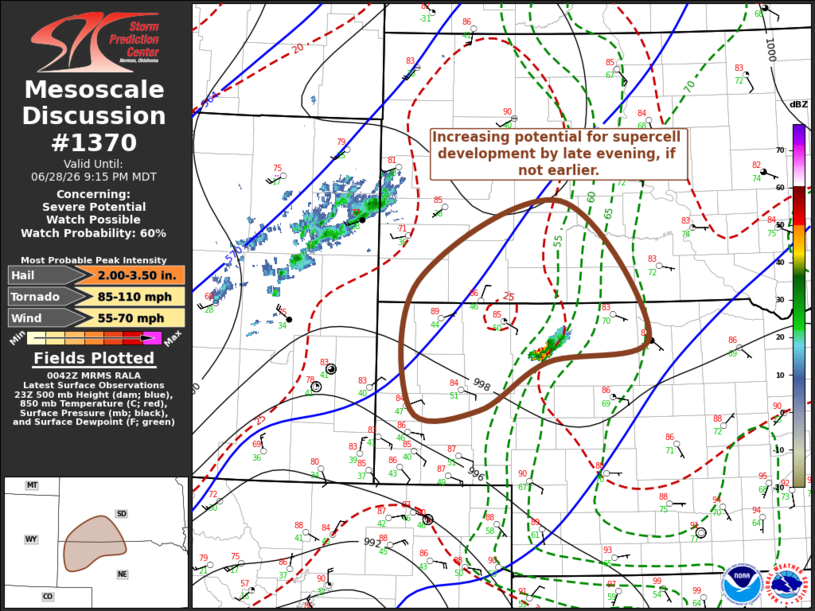
Areas affected...parts pf northwestern Nebraska into southwestern
South Dakota
Concerning...Severe potential...Watch possible
Valid 290044Z - 290315Z
Probability of Watch Issuance...60 percent
SUMMARY...Increasing strong thunderstorm development appears
probable by late evening, if not earlier. This may, at least
initially, include evolving supercells with large hail and at least
some potential for tornadoes. Although timing remains a bit
uncertain, it is appearing more probable that a severe weather watch
will be needed at some point this evening.
DISCUSSION...Within larger-scale mid/upper troughing across the
West, another significant short wave trough is now turning eastward
through the eastern Great Basin and will continue to gradually pivot
east-northeastward through this evening. This may be preceded by
one or two much more subtle perturbations within downstream cyclonic
flow across the Colorado Rockies toward the Black Hills vicinity,
with at least attempts at isolated thunderstorm development now
underway northwest of Mullen NE.
This storm appears to be developing near the leading edge of
westerly low-level moisture return toward the high plains between
the Cheyenne Ridge and Black Hills vicinity, where forcing for
ascent associated with strengthening warm advection centered around
the 700 mb level is forecast to focus by 02-04Z. Coupled with
strengthening deep-layer and low-level shear near the nose of an
intensifying low-level jet (50-60+ kt around 850 mb), the potential
for supercell thunderstorm development seems likely to increase
through mid to late evening, aided by inflow of air characterized by
increasingly sizable potential instability.
..Kerr/Thompson.. 06/29/2026
...Please see www.spc.noaa.gov for graphic product...
ATTN...WFO...ABR...LBF...UNR...CYS...
LAT...LON 43240344 44120131 42620001 42340153 41810252 41820354
43240344
MOST PROBABLE PEAK TORNADO INTENSITY...85-110 MPH
MOST PROBABLE PEAK WIND GUST...55-70 MPH
MOST PROBABLE PEAK HAIL SIZE...2.00-3.50 IN
|
|
|
Top/All Mesoscale Discussions/Forecast Products/Home |
|
Source link