| Mesoscale Discussion 1361 | |
| < Previous MD | |

|
|
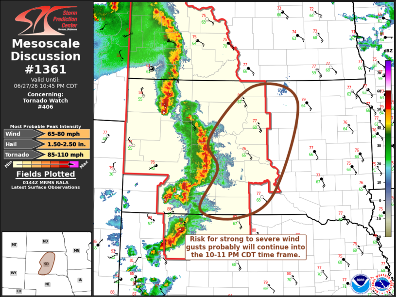
Mesoscale Discussion 1361 NWS Storm Prediction Center Norman OK 0846 PM CDT Sat Jun 27 2026 Areas affected...parts of central South Dakota Concerning...Tornado Watch 406... Valid 280146Z - 280345Z The severe weather threat for Tornado Watch 406 continues. SUMMARY...A cluster of storms may continue to pose a risk for strong to severe wind gusts across much of central South Dakota through 10-11 PM CDT. DISCUSSION...Forcing for ascent associated with weak short wave troughing progressing through 30-40 kt difluent, southwesterly flow around 500 mb may maintain northeastward progression of an ongoing cluster of storms across much of central South Dakota, despite increasing inhibition for moist boundary-layer parcels. The corridor of stronger potential instability (from which updraft inflow is emanating) is narrow, but Rapid Refresh suggests it may be developing slowly eastward. It still probably will be overtaken by the convective outflow somewhere across central into eastern South Dakota, leading to at least gradual weakening of convection. However, until then, convection will probably continue to pose a risk for strong to severe wind gusts. ..Kerr.. 06/28/2026 ...Please see www.spc.noaa.gov for graphic product... ATTN...WFO...FSD...ABR...LBF...UNR... LAT...LON 44670145 45810009 45479870 43489945 42920061 43110169 43990117 44670145 MOST PROBABLE PEAK TORNADO INTENSITY...85-110 MPH MOST PROBABLE PEAK WIND GUST...65-80 MPH MOST PROBABLE PEAK HAIL SIZE...1.50-2.50 IN |
|
|
Top/All Mesoscale Discussions/Forecast Products/Home |
|
Source link