| Mesoscale Discussion 136 | |
| < Previous MD | |

|
|
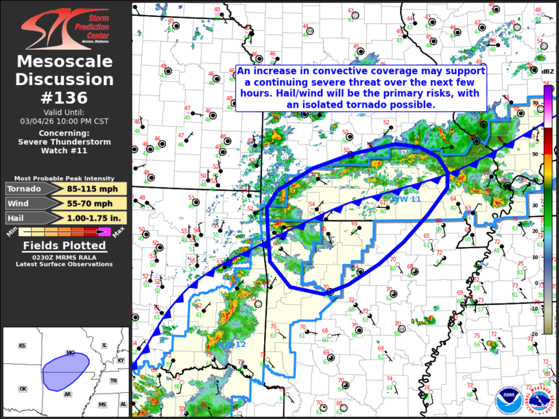
Mesoscale Discussion 0136 NWS Storm Prediction Center Norman OK 0833 PM CST Wed Mar 04 2026 Areas affected...portions of southern Missouri and northern Arkansas Concerning...Severe Thunderstorm Watch 11... Valid 050233Z - 050400Z The severe weather threat for Severe Thunderstorm Watch 11 continues. SUMMARY...Increasing mid-level ascent will overspread portions of southern Missouri and northern Arkansas over the next 1-2 hours ahead of an approaching shortwave mid-level trough. This upper-level forcing coupled with a strengthening southerly low-level jet could support a continuing severe weather threat over the next few hours, with hail/wind the primary hazards. WW0011 will be locally extended across portions of northern Arkansas. DISCUSSION...Ongoing convection across eastern Oklahoma and northwestern Arkansas will progress northeastward over the next 1-2 hours within a warm sector characterized by 1000-1500 J/kg MLCAPE and 40-50 kts of effective bulk shear. Increased low-level hodograph curvature owing to a strengthening, southerly low-level jet (as sampled by regional VWPs) and steep mid-level lapse rates (around 7 C/km) could support a continuing threat for large hail and perhaps a tornado or two. With time, expected upscale growth of this convection into one or more linear segments may foster an increasing threat for damaging wind gusts. Simultaneously, the strengthening low-level jet will support increasing convective coverage along and north of a surface frontal boundary currently analyzed across southern Missouri. MUCAPE of 1000-1500 J/kg amidst steep mid-level lapse rates of 7-7.5 C/km and effective bulk shear of 30-40 kts may support a continuing threat for large hail north of this boundary. Given the potential for the continuing severe threat, WW0011 will be locally extended across portions of northern Arkansas. ..Chalmers/Lyons/Hart.. 03/05/2026 ...Please see www.spc.noaa.gov for graphic product... ATTN...WFO...PAH...LSX...LZK...SGF...TSA... LAT...LON 35209323 35339395 35769439 36239443 36719448 37019424 37429346 37669261 37839166 37789113 37599073 37339052 37069054 36599098 36129150 35749203 35379270 35209323 MOST PROBABLE PEAK TORNADO INTENSITY...85-115 MPH MOST PROBABLE PEAK WIND GUST...55-70 MPH MOST PROBABLE PEAK HAIL SIZE...1.00-1.75 IN |
|
|
Top/All Mesoscale Discussions/Forecast Products/Home |
|
Source link