| Mesoscale Discussion 1357 | |
| < Previous MD | |

|
|
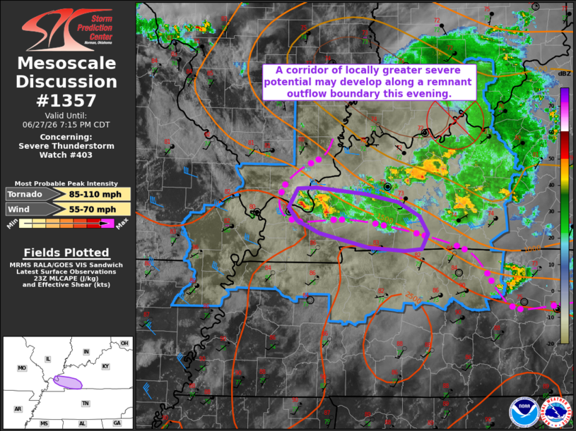
Mesoscale Discussion 1357 NWS Storm Prediction Center Norman OK 0618 PM CDT Sat Jun 27 2026 Areas affected...portions of western Kentucky Concerning...Severe Thunderstorm Watch 403... Valid 272318Z - 280015Z The severe weather threat for Severe Thunderstorm Watch 403 continues. SUMMARY...A corridor of locally greater severe potential may exist across portions of Severe Thunderstorm Watch 403 along remnant outflow boundary. DISCUSSION...Latest surface analysis places a remnant outflow boundary from just south of Paducah, Kentucky, into northern Tennessee. Convection along this boundary in the vicinity of PAH has exhibited marginal supercell structures with weak rotation signatures over the past 1-2 hours. A moist and unstable air mass south of the remnant boundary aided by 40-50 kts of mid-level flow (sampled by regional VWPs) and effective shear of around 30 kts along the southern flank of two mid-level MCVs will continue to support marginal supercell structures through this evening, with the latest high-res guidance suggesting that this convection may continue to progress along this boundary. In this scenario, a corridor of locally greater severe potential may develop, with the potential for water-loaded downbursts and damaging wind gusts. A brief tornado or two is also possible given enhanced low-level shear along this boundary (~100 m2/s2 0-500 m SRH sampled downstream of the aforementioned convection by the HPX/OHX VWPs). ..Chalmers.. 06/27/2026 ...Please see www.spc.noaa.gov for graphic product... ATTN...WFO...LMK...OHX...PAH... LAT...LON 37338864 37338839 37268771 37178725 37018696 36828683 36658693 36628717 36678766 36828834 36978866 37118878 37338864 MOST PROBABLE PEAK TORNADO INTENSITY...85-110 MPH MOST PROBABLE PEAK WIND GUST...55-70 MPH |
|
|
Top/All Mesoscale Discussions/Forecast Products/Home |
|
Source link