| Mesoscale Discussion 1355 | |
| < Previous MD | |

|
|
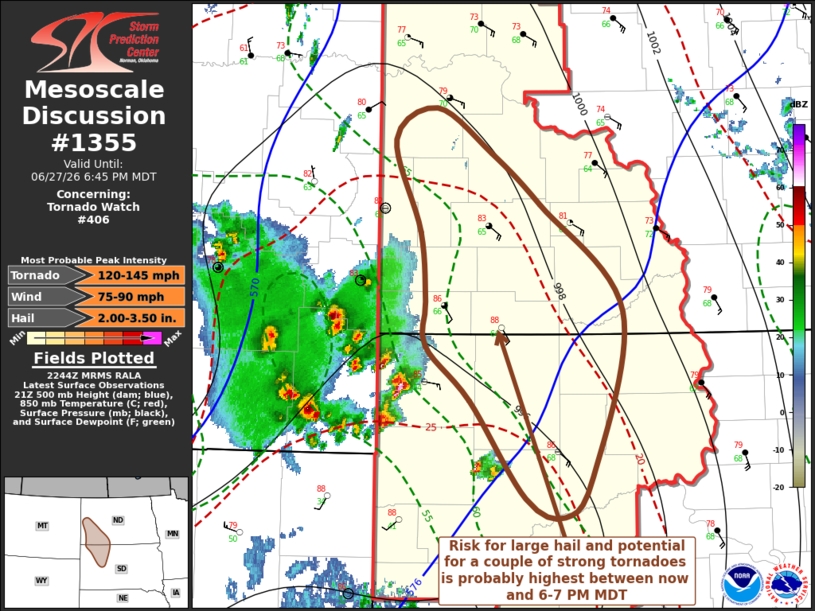
Mesoscale Discussion 1355 NWS Storm Prediction Center Norman OK 0547 PM CDT Sat Jun 27 2026 Areas affected...parts of the western Dakotas Concerning...Tornado Watch 406... Valid 272247Z - 280045Z The severe weather threat for Tornado Watch 406 continues. SUMMARY...The risk for supercells capable of producing sizable hail and increasing potential for a couple strong tornadoes is probably highest between now and 6-7 PM MDT. DISCUSSION...Strong thunderstorm development is now well underway within clusters developing north and northeast of the Big Horn Mountains, and within deep surface troughing, near the northeastern Montana international border. More recent, and still discrete, storm initiation has been occurring in the vicinity of the surface trough axis near the southeastern Montana/Dakotas state border through western South Dakota to the north of the Black Hills. Immediately to the north and east of the latter activity, boundary-layer instability is currently maximized in a narrow corridor and appears to include CAPE in excess of 3000 J/kg. Prior to the arrival of consolidating and strengthening outflow emanating from the upstream convection, there appears a couple of hour window for intensifying discrete storm development, in the presence of strong deep-layer shear beneath 40-50 kt southerly flow around 500 mb. Some further strengthening of south-southeasterly flow around 850 mb through 00-01Z may contribute to enlarging clockwise-curved low-level hodographs increasingly conducive to the development of tornadoes, in addition to large hail and localized strong downbursts. ..Kerr.. 06/27/2026 ...Please see www.spc.noaa.gov for graphic product... ATTN...WFO...ABR...BIS...UNR... LAT...LON 45840350 46200350 46740357 47460386 47720339 47360277 46960220 46110128 44810162 44490194 44650237 45410301 45840350 MOST PROBABLE PEAK TORNADO INTENSITY...120-145 MPH MOST PROBABLE PEAK WIND GUST...75-90 MPH MOST PROBABLE PEAK HAIL SIZE...2.00-3.50 IN |
|
|
Top/All Mesoscale Discussions/Forecast Products/Home |
|
Source link