| Mesoscale Discussion 1349 | |
| < Previous MD | |

|
|
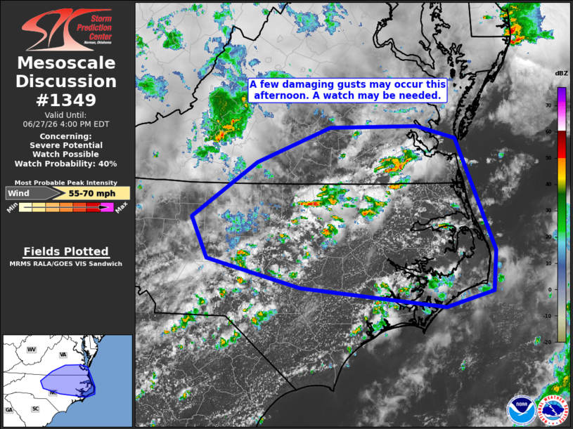
   Mesoscale Discussion 1349
   NWS Storm Prediction Center Norman OK
   0106 PM CDT Sat Jun 27 2026

   Areas affected...southern Virginia and northern North Carolina

   Concerning...Severe potential...Watch possible

   Valid 271806Z - 272000Z

   Probability of Watch Issuance...40 percent

   SUMMARY...A few damaging gusts may occur this afternoon across
   portions of southern Virginia and northern North Carolina. A watch
   may be needed.

   DISCUSSION...A deep, moist air mass is in place across the
   southeastern CONUS south of a residual boundary, and convective
   temperatures have been reached across portions of southern Virginia
   and northern North Carolina, resulting in scattered thunderstorm
   development. The flow aloft in the vicinity of the storms is
   relatively modest with generally better flow farther north. This
   results in relatively weak shear across much of the area, though
   sufficient for multicell clusters. The very moist air mass in place
   (precipitable water near or above 2 inches) may result in
   water-loaded downdrafts, leading to a few damaging gusts. As the
   afternoon progresses, storms will likely cluster together,
   increasing the potential for damaging gusts. A watch may be needed
   this afternoon.

   ..Supinie/Guyer.. 06/27/2026

   ...Please see www.spc.noaa.gov for graphic product...

   ATTN...WFO...AKQ...MHX...RAH...RNK...

   LAT...LON   34927617 35177849 35567999 36108024 36817920 37287803
               37307662 37137600 36517572 35667536 35137541 34927617

   MOST PROBABLE PEAK WIND GUST...55-70 MPH
|
|
|
Top/All Mesoscale Discussions/Forecast Products/Home |
|
Source link