| Mesoscale Discussion 134 | |
| < Previous MD | |
|
|
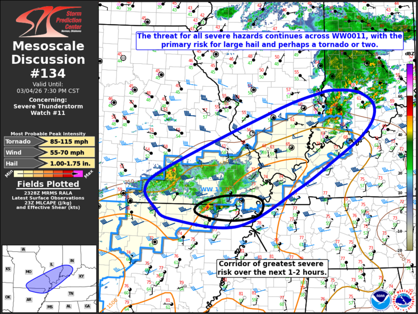
Mesoscale Discussion 0134 NWS Storm Prediction Center Norman OK 0530 PM CST Wed Mar 04 2026 Areas affected...portions of the Ozarks into the lower Ohio River Valley Concerning...Severe Thunderstorm Watch 11... Valid 042330Z - 050130Z The severe weather threat for Severe Thunderstorm Watch 11 continues. SUMMARY...The severe threat for all hazards continues across Severe Thunderstorm Watch #11 until 0300 UTC, with the primary threat for large hail and perhaps a tornado or two. DISCUSSION...MLCAPE of 1000-1500 J/kg coupled with effective bulk shear of 30-40 kts and modestly steep mid-level lapse rates of around 7 C/km will continue to favor a threat for severe hail across WW0011, primarily across portions of southern Missouri and northern Arkansas where an ongoing, isolated supercell may persist for at least another 1-2 hours. Increasing low-level flow is also expected to yield a modest increase to low-level hodograph curvature over the next few hours. With additional development across the southwestern portions of the Watch area possible, this will support at least some potential for an isolated tornado in addition to the continuing hail/wind threats, particularly where developing storms are able to maintain a more discrete storm mode. Farther northeast, a cluster of ongoing thunderstorms continues across portions of southern Illinois/Indiana along and north of the surface boundary. While instability and mid-level lapse rates are more limited (approximately 500 J/kg MUCAPE and 6 C/km, respectively, per latest mesoanalysis), modest warm air advection within the 925-850 mb layer atop the frontal boundary coupled with effective bulk shear around 30 knots will continue to support the risk for isolated severe hail over the next couple of hours. A downstream watch is not anticipated at this time. ..Chalmers/Lyons.. 03/04/2026 ...Please see www.spc.noaa.gov for graphic product... ATTN...WFO...LMK...IND...PAH...ILX...MEG...LSX...LZK...SGF... LAT...LON 36149200 36409249 36859278 37379209 38668902 39068772 39128726 39078658 38828613 38458614 38028653 37518728 36898830 36009008 36149200 MOST PROBABLE PEAK TORNADO INTENSITY...85-115 MPH MOST PROBABLE PEAK WIND GUST...55-70 MPH MOST PROBABLE PEAK HAIL SIZE...1.00-1.75 IN |
|
|
Top/All Mesoscale Discussions/Forecast Products/Home |
|
Source link