| Mesoscale Discussion 1334 | |
| < Previous MD Next MD > | |

|
|
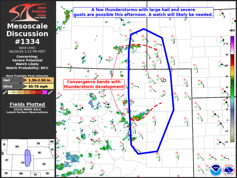
   Mesoscale Discussion 1334
   NWS Storm Prediction Center Norman OK
   0313 PM CDT Fri Jun 26 2026

   Areas affected...portions of northeastern Colorado...southeastern
   Wyoming...and far western Nebraska

   Concerning...Severe potential...Watch likely

   Valid 262013Z - 262115Z

   Probability of Watch Issuance...80 percent

   SUMMARY...A few thunderstorms with large hail and severe gusts are
   possible this afternoon across portions of northeastern Colorado,
   southeastern Wyoming, and far western Nebraska. A watch may be
   needed to cover this threat.

   DISCUSSION...A large upper trough is in place across the
   northwestern CONUS with a subtle jet pushing eastward over the
   central Rockies this afternoon. Storms are preferentially developing
   along a couple convergence boundaries across portions of the High
   Plains. The flow enhancement from the jet results in lengthened
   hodographs, which should result in enough shear for at least a few
   supercells.

   With any supercells that do form, a few instances of large hail are
   possible due to the straight hodographs and relatively low freezing
   levels. Storms may cluster as the afternoon progresses, which may
   result in a threat for severe gusts due to the dry boundary layer
   and modest low- and mid-level flow. One limiting factor for wind is
   some residual inhibition across parts of the High Plains, though
   this is expected to erode with continued strong heating. A watch
   will likely be needed to cover this threat.

   ..Supinie/Guyer.. 06/26/2026

   ...Please see www.spc.noaa.gov for graphic product...

   ATTN...WFO...GLD...PUB...BOU...CYS...

   LAT...LON   40180486 41600487 42170478 42370419 42060336 40850299
               39610286 38200360 38100442 38410473 40180486

   MOST PROBABLE PEAK WIND GUST...55-70 MPH
   MOST PROBABLE PEAK HAIL SIZE...1.50-2.50 IN
|
|
|
Top/All Mesoscale Discussions/Forecast Products/Home |
|
Source link