| Mesoscale Discussion 1329 | |
| < Previous MD | |

|
|
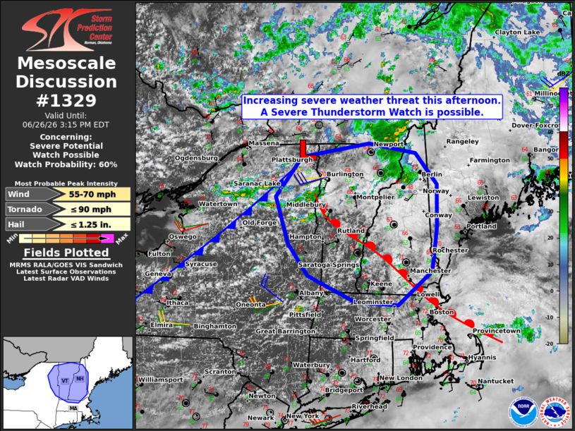
   Mesoscale Discussion 1329
   NWS Storm Prediction Center Norman OK
   1220 PM CDT Fri Jun 26 2026

   Areas affected...northern and central New England

   Concerning...Severe potential...Watch possible

   Valid 261720Z - 261915Z

   Probability of Watch Issuance...60 percent

   SUMMARY...The threat for widely scattered severe storms capable of
   large hail, damaging winds, and perhaps a brief tornado is expected
   to increase this afternoon. Convective trends are being monitored
   for a possible Severe Thunderstorm Watch.

   DISCUSSION...Forcing for ascent attendant to a short-wave trough
   moving along the St. Lawrence Valley coupled in conjunction with a
   warming/ destabilizing, pre-frontal air mass is contributing to
   deepening cumulus and early thunderstorm development over the
   Adirondack Mountains as of 17z. Cloud breaks within the immediate
   downstream air mass along and east of the Champlain Valley area
   expected to aid in further air mass destabilization this afternoon
   with MLCAPE increasing to 1000 J/kg along and south of a subtle warm
   front/ differential heating zone lifting north through VT and NH.

   Current expectations are for the ongoing storms to gradually
   intensify while spreading east into the discussion area with
   additional storm development possible along favored terrain and/or
   the warm front. Mid/upper-level wind fields are forecast to
   strengthen through the afternoon with an associated increase in
   deep-layer shear. Forecast hodographs indicate a largely
   unidirectional shear profile, suggesting the potential for splitting
   supercells capable of marginally severe hail and locally damaging
   wind gusts. While ambient low-level shear is expected to remain
   modest, some brief tornado potential could materialize with any
   supercell that can favorably interact with the warm front.

   ..Mead/Guyer.. 06/26/2026

   ...Please see www.spc.noaa.gov for graphic product...

   ATTN...WFO...GYX...BOX...BTV...ALY...

   LAT...LON   44207424 44817370 45017227 44877127 44397082 43737084
               43057095 42547166 42587256 42987356 43487398 44207424

   MOST PROBABLE PEAK TORNADO INTENSITY...UP TO 90 MPH
   MOST PROBABLE PEAK WIND GUST...55-70 MPH
   MOST PROBABLE PEAK HAIL SIZE...UP TO 1.25 IN
|
|
|
Top/All Mesoscale Discussions/Forecast Products/Home |
|
Source link