| Mesoscale Discussion 1328 | |
| < Previous MD | |

|
|
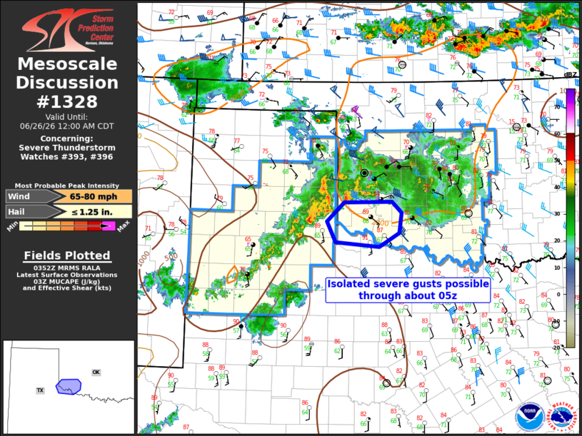
Mesoscale Discussion 1328 NWS Storm Prediction Center Norman OK 1054 PM CDT Thu Jun 25 2026 Areas affected...Extreme northwest Texas and southwest Oklahoma Concerning...Severe Thunderstorm Watch 393...396... Valid 260354Z - 260500Z The severe weather threat for Severe Thunderstorm Watch 393, 396 continues. SUMMARY...Isolated severe gusts will be possible through about 05z across far northwest Texas and southwest Oklahoma. WW #393 will be allowed to expire at 04z. DISCUSSION...The primary threat for severe storms with 60+ mph outflow gusts is now confined to far southwest OK and northwest TX, where outflow interactions are occurring. Storm/outflow mergers will lead to temporary strengthening of updrafts and subsequent downdrafts in an environment of lingering moderate buoyancy and steep lapse rates. However, the longer term trend should be for gradual storm weakening and a reduction in the severe threat by and after about 05z. ..Thompson.. 06/26/2026 ...Please see www.spc.noaa.gov for graphic product... ATTN...WFO...OUN...LUB...AMA... LAT...LON 34389867 34159909 34239999 34590018 34919982 34929881 34739861 34389867 MOST PROBABLE PEAK WIND GUST...65-80 MPH MOST PROBABLE PEAK HAIL SIZE...UP TO 1.25 IN |
|
|
Top/All Mesoscale Discussions/Forecast Products/Home |
|
Source link