| Mesoscale Discussion 1327 | |
| < Previous MD | |

|
|
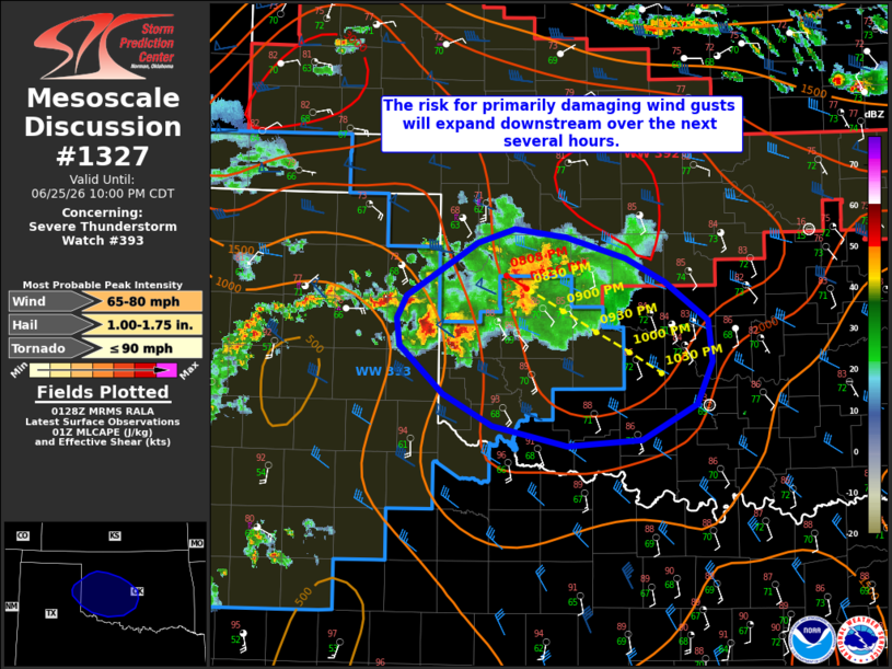
Mesoscale Discussion 1327 NWS Storm Prediction Center Norman OK 0830 PM CDT Thu Jun 25 2026 Areas affected...portions of the eastern Texas Panhandle into western and central Oklahoma Concerning...Severe Thunderstorm Watch 393... Valid 260130Z - 260300Z The severe weather threat for Severe Thunderstorm Watch 393 continues. SUMMARY...The risk for primarily damaging wind gusts will expand eastward from the eastern Texas Panhandle/western Oklahoma into central Oklahoma over the next several hours. DISCUSSION...A convective complex continues to evolve across the eastern Texas Panhandle/far western Oklahoma as of 0130 UTC, with a mixed mode of clusters/supercells noted via regional radar imagery. While these storms have been slow to consolidate thus far, continued cold pool development has yielded a more appreciable forward acceleration over the past 30-60 minutes. Low-level inhibition has begun to increase with the loss of diurnal heating, but a strengthening southerly, low-level jet and effective shear around 35-40 kts should help sustain this cluster as it progresses southeastward over the next couple of hours. The primary threat will be for damaging wind gusts (with a significant gust or two possible, primarily in the near-term). Isolated large hail and perhaps a brief tornado also cannot be ruled out, especially along the southern/southwestern flank of the complex where semi-discrete supercell structures have been maintained. A downstream Severe Thunderstorm Watch or extension of WW393 will eventually be needed. ..Chalmers/Mosier.. 06/26/2026 ...Please see www.spc.noaa.gov for graphic product... ATTN...WFO...OUN...AMA... LAT...LON 35630033 36029971 36089961 36219921 36149868 35959807 35759766 35429722 35079717 34719734 34419790 34369868 34549944 34809996 35220041 35450044 35630033 MOST PROBABLE PEAK TORNADO INTENSITY...UP TO 90 MPH MOST PROBABLE PEAK WIND GUST...65-80 MPH MOST PROBABLE PEAK HAIL SIZE...1.00-1.75 IN |
|
|
Top/All Mesoscale Discussions/Forecast Products/Home |
|
Source link