|
|
| Mesoscale Discussion 1323 | |
| < Previous MD Next MD > | |

|
|
   Mesoscale Discussion 1323
   NWS Storm Prediction Center Norman OK
   0324 PM CDT Tue Jun 18 2024

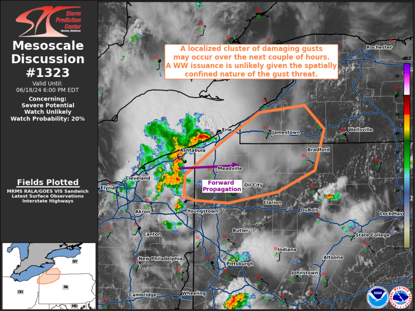
   Areas affected...portions of far northwestern Pennsylvania into far
   southwestern New York

   Concerning...Severe potential...Watch unlikely

   Valid 182024Z - 182200Z

   Probability of Watch Issuance...20 percent

   SUMMARY...A localized concentration of damaging gusts is possible
   over the next few hours along the PA/NY border region. Given the
   spatially and temporally confined nature of the damaging gust
   threat, a WW issuance remains unlikely.

   DISCUSSION...An organized cluster of thunderstorms with a history of
   damaging gusts (and at least one measured 50+ kt gust) has developed
   over far northeastern OH. This cluster is slowly propagating
   northeast as convective outflow spreads to the southeast,
   overturning the ambient airmass in the process. Weak deep-layer
   west-southwesterly flow pivoting around the Mid-Atlantic anticyclone
   suggests that the ongoing cluster, should it persist, will continue
   moving east-northeast. As such, the northeast flank of the ongoing
   cluster may not gust out and undercut convection for at least a few
   more hours. In this time-frame, 3000+ J/kg MLCAPE will support
   stronger storm cores capable of producing a focused corridor locally
   damaging gusts. However, the damaging gusts should be contained
   within a small area, and convection may become outflow dominant and
   undercut sooner than expected. A WW issuance remains unlikely in the
   short-term, but convective trends will continue to be monitored for
   the possibility of greater upscale growth and subsequent damaging
   wind potential.

   ..Squitieri/Gleason.. 06/18/2024

   ...Please see www.spc.noaa.gov for graphic product...

   ATTN...WFO...BUF...CTP...PBZ...CLE...

   LAT...LON   41608068 42008008 42387943 42487866 42177834 41667850
               41387912 41257994 41278051 41338069 41608068
|
|
|
Top/All Mesoscale Discussions/Forecast Products/Home |
|


